Lases geodata
Lases (Trentino-Alto Adige) is a seat of a third-order administrative division; located in Italy in Europe/Rome (GMT+2) time zone. With population of 539 people, there are 9552 cities with bigger population in this country. Compared to other cities in Italy, 94.8% of cities are located further ↓South; 54.2% of cities are located further →East and 86.3% of cities have lower elevation than Lases. Note1
Administrative division(s):
- Level 1: Trentino-Alto Adige
- Level 2: Provincia autonoma di Trento
- Level 3: Lona-Lases


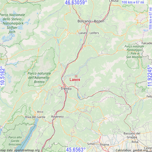
Lases GPS coordinates[2]
46° 8' 44.16" North, 11° 13' 9.552" East
| Map corner | latitude | longitude |
|---|---|---|
| Upper-left | 46.63059°, | 10.5162° |
| Center: | 46.1456°, | 11.21932° |
| Lower-right: | 45.6563°, | 11.92245° |
| Map W x H: | 108.3×108.3 km | = 67.3×67.3mi |
| max Lat: | 47.04031° ⇑5.2% North |
| Lases: | 46.1456° |
| min Lat: | ⇓94.8% South 35.50142° |
| min Long | Lases | max Long |
| 6.69888° | 11.21932° | 18.48682° |
| W 45.8%⇐ | ⇒54.2% E |
Elevation
Elevation of Lases is 638 m = 2093 ft, and this is 331.3 m = 1087 ft above average elevation for this country.
| Max E: |
2085 m = 6841 ft | 13.7% |
| Lases | 638 m 2093 ft | |
| Avg. | 306.7 m = 1006 ft | |
Min E: |
-4 m = -13 ft | 86.3% |
See also: Italy elevation on elevation.city.
Geographical zone
Lases is located in North temperate zone (between Tropic of Cancer and the Arctic Circle). Distance of this North polar circle is 2270.3 km =1410.7 mi to North.| Distance of | km | miles | from Lases |
|---|---|---|---|
| North Pole | 4876.2 | 3029.9 | to North |
| Arctic Circle | 2270.3 | 1410.7 | to North |
| Tropic Cancer | 2525 | 1569 | to South |
| Equator | 5130.9 | 3188.2 | to South |


Nearby cities:
15 places around Lases: (largest is in red/bold)
• Albiano
1.9 km =1.2 mi,  266°
266°
• Baselga di Pinè
2.5 km =1.6 mi,  124°
124°
• Cembra
3.3 km =2.1 mi,  3°
3°
• Civezzano
6.6 km =4.1 mi,  203°
203°
• Faver
4.2 km =2.6 mi,  19°
19°
• Fornace
3.2 km =2 mi, 196°
• Giovo
5.2 km =3.2 mi,  282°
282°
• Lisignago
3 km =1.9 mi,  304°
304°
• Lona-Lases
0.2 km =0.1 mi,  172°
172°
• Miola di Pinè
3.1 km =1.9 mi,  133°
133°
• Palù
6.1 km =3.8 mi, 283°
• Rizzolaga-Campolongo
4.1 km =2.5 mi,  84°
84°
• Segonzano
5.9 km =3.7 mi,  32°
32°
• Seregnano
6.3 km =3.9 mi, 195°
• Verla
5.3 km =3.3 mi,  285°
285°
Sources, notices
• [Note1] Compared only with cities in Italy existing in our database
• [Src1] Map data: © OpenStreetMap contributors (CC-BY-SA)
• [Src2] Other city data from geonames.org with taken over terms of usage.
• [Src3] Geographical zone / Annual Mean Temperature by Robert A. Rohde @ Wikipedia
