Palena geodata
Palena (Abruzzo) is a seat of a third-order administrative division; located in Italy in Europe/Rome (GMT+2) time zone. With population of 1,308 people, there are 5610 cities with bigger population in this country. Compared to other cities in Italy, 70.5% of cities are located further ↑North; 79.2% of cities are located further ←West and 92.8% of cities have lower elevation than Palena. Note1


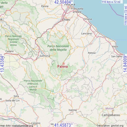
Palena GPS coordinates[2]
41° 59' 0.708" North, 14° 8' 13.056" East
| Map corner | latitude | longitude |
|---|---|---|
| Upper-left | 42.50404°, | 13.43384° |
| Center: | 41.98353°, | 14.13696° |
| Lower-right: | 41.45873°, | 14.84009° |
| Map W x H: | 116.2×116.2 km | = 72.2×72.2mi |
| max Lat: | 47.04031° ⇑70.5% North |
| Palena: | 41.98353° |
| min Lat: | ⇓29.5% South 35.50142° |
| min Long | Palena | max Long |
| 6.69888° | 14.13696° | 18.48682° |
| W 79.2%⇐ | ⇒20.8% E |
Elevation
Elevation of Palena is 793 m = 2602 ft, and this is 486.3 m = 1595 ft above average elevation for this country.
| Max E: |
2085 m = 6841 ft | 7.2% |
| Palena | 793 m 2602 ft | |
| Avg. | 306.7 m = 1006 ft | |
Min E: |
-4 m = -13 ft | 92.8% |
See also: Italy elevation on elevation.city.
Geographical zone
Palena is located in North temperate zone (between Tropic of Cancer and the Arctic Circle). Distance of this Northern Tropic circle is 2062.2 km =1281.4 mi to South.| Distance of | km | miles | from Palena |
|---|---|---|---|
| North Pole | 5338.9 | 3317.4 | to North |
| Arctic Circle | 2733 | 1698.2 | to North |
| Tropic Cancer | 2062.2 | 1281.4 | to South |
| Equator | 4668.1 | 2900.6 | to South |


Nearby cities:
15 places around Palena: (largest is in red/bold)
• Campo di Giove
8.6 km =5.3 mi,  290°
290°
• Cansano
10.4 km =6.5 mi,  282°
282°
• Civitella Messer Raimondo
13.5 km =8.4 mi,  29°
29°
• Colledimacine
5.7 km =3.5 mi,  66°
66°
• Fara San Martino
13.5 km =8.4 mi, 26°
• Gamberale
10.5 km =6.5 mi,  145°
145°
• Gessopalena
13.8 km =8.6 mi,  54°
54°
• Lama dei Peligni
7.7 km =4.8 mi, 32°
• Lettopalena
2.7 km =1.7 mi,  37°
37°
• Montenerodomo
9.5 km =5.9 mi,  94°
94°
• Pescocostanzo
12.2 km =7.6 mi,  208°
208°
• Pizzoferrato
10.7 km =6.6 mi,  129°
129°
• Rivisondoli
13.9 km =8.6 mi,  204°
204°
• Taranta Peligna
5 km =3.1 mi, 34°
• Torricella Peligna
11 km =6.8 mi, 65°
Sources, notices
• [Note1] Compared only with cities in Italy existing in our database
• [Src1] Map data: © OpenStreetMap contributors (CC-BY-SA)
• [Src2] Other city data from geonames.org with taken over terms of usage.
• [Src3] Geographical zone / Annual Mean Temperature by Robert A. Rohde @ Wikipedia
