Palagiano geodata
Palagiano (Apulia) is a seat of a third-order administrative division; located in Italy in Europe/Rome (GMT+2) time zone. With population of 15,388 people, there are 591 cities with bigger population in this country. Compared to other cities in Italy, 83.6% of cities are located further ↑North; 98.1% of cities are located further ←West and 82.2% of cities have higher elevation than Palagiano. Note1


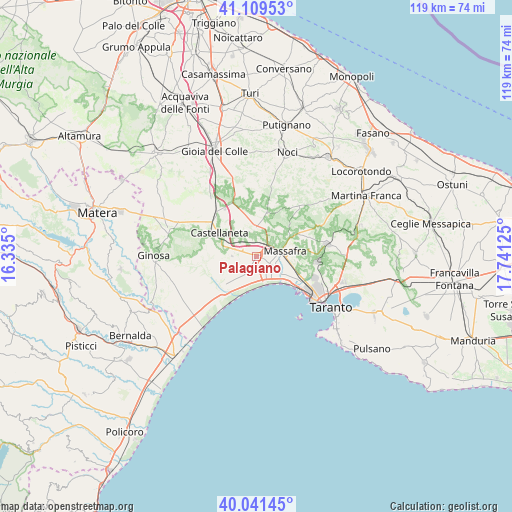
Palagiano GPS coordinates[2]
40° 34' 39.432" North, 17° 2' 17.232" East
| Map corner | latitude | longitude |
|---|---|---|
| Upper-left | 41.10953°, | 16.335° |
| Center: | 40.57762°, | 17.03812° |
| Lower-right: | 40.04145°, | 17.74125° |
| Map W x H: | 118.8×118.8 km | = 73.8×73.8mi |
| max Lat: | 47.04031° ⇑83.6% North |
| Palagiano: | 40.57762° |
| min Lat: | ⇓16.4% South 35.50142° |
| min Long | Palagiano | max Long |
| 6.69888° | 17.03812° | 18.48682° |
| W 98.1%⇐ | ⇒1.9% E |
Elevation
Elevation of Palagiano is 41 m = 135 ft, and this is 265.7 m = 872 ft below average elevation for this country.
| Max E: |
2085 m = 6841 ft | 82.2% |
| Avg. | 306.7 m = 1006 ft | |
| Palagiano | 41 m = 135 ft | |
Min E: |
-4 m = -13 ft | 17.8% |
See also: Italy elevation on elevation.city.
Geographical zone
Palagiano is located in North temperate zone (between Tropic of Cancer and the Arctic Circle). Distance of this Northern Tropic circle is 1905.9 km =1184.3 mi to South.| Distance of | km | miles | from Palagiano |
|---|---|---|---|
| North Pole | 5495.3 | 3414.6 | to North |
| Arctic Circle | 2889.4 | 1795.4 | to North |
| Tropic Cancer | 1905.9 | 1184.3 | to South |
| Equator | 4511.8 | 2803.5 | to South |


Nearby cities:
15 places around Palagiano: (largest is in red/bold)
• Castellaneta
10.5 km =6.5 mi,  302°
302°
• Castellaneta Marina
14.9 km =9.3 mi,  215°
215°
• Crispiano
16.7 km =10.4 mi,  79°
79°
• Ginosa
23.8 km =14.8 mi,  269°
269°
• Laterza
20.9 km =13 mi,  285°
285°
• Lido Azzurro
10.9 km =6.8 mi,  128°
128°
• Marina di Ginosa
21.3 km =13.2 mi, 218°
• Massafra
6.7 km =4.2 mi, 81°
• Mottola
6.8 km =4.2 mi,  357°
357°
• Noci
25.1 km =15.6 mi,  17°
17°
• Palagianello
6.1 km =3.8 mi, 304°
• Paolo VI
20.9 km =13 mi,  107°
107°
• Parco di Guerra
9.5 km =5.9 mi,  90°
90°
• Statte
14.8 km =9.2 mi, 111°
• Taranto
21.7 km =13.5 mi, 125°
Sources, notices
• [Note1] Compared only with cities in Italy existing in our database
• [Src1] Map data: © OpenStreetMap contributors (CC-BY-SA)
• [Src2] Other city data from geonames.org with taken over terms of usage.
• [Src3] Geographical zone / Annual Mean Temperature by Robert A. Rohde @ Wikipedia
