Ginosa geodata
Ginosa (Apulia) is a seat of a third-order administrative division; located in Italy in Europe/Rome (GMT+2) time zone. With population of 16,151 people, there are 563 cities with bigger population in this country. Compared to other cities in Italy, 83.6% of cities are located further ↑North; 97.4% of cities are located further ←West and 53.2% of cities have lower elevation than Ginosa. Note1


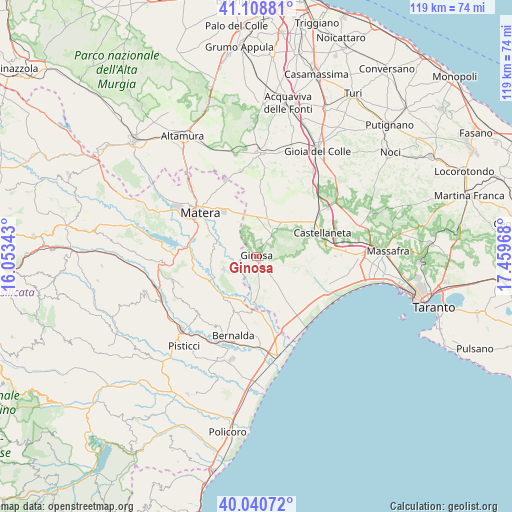
Ginosa GPS coordinates[2]
40° 34' 36.84" North, 16° 45' 23.58" East
| Map corner | latitude | longitude |
|---|---|---|
| Upper-left | 41.10881°, | 16.05343° |
| Center: | 40.5769°, | 16.75655° |
| Lower-right: | 40.04072°, | 17.45968° |
| Map W x H: | 118.8×118.8 km | = 73.8×73.8mi |
| max Lat: | 47.04031° ⇑83.6% North |
| Ginosa: | 40.5769° |
| min Lat: | ⇓16.4% South 35.50142° |
| min Long | Ginosa | max Long |
| 6.69888° | 16.75655° | 18.48682° |
| W 97.4%⇐ | ⇒2.6% E |
Elevation
Elevation of Ginosa is 254 m = 833 ft, and this is 52.7 m = 173 ft below average elevation for this country.
| Max E: |
2085 m = 6841 ft | 46.8% |
| Avg. | 306.7 m = 1006 ft | |
| Ginosa | 254 m = 833 ft | |
Min E: |
-4 m = -13 ft | 53.2% |
See also: Italy elevation on elevation.city.
Geographical zone
Ginosa is located in North temperate zone (between Tropic of Cancer and the Arctic Circle). Distance of this Northern Tropic circle is 1905.8 km =1184.2 mi to South.| Distance of | km | miles | from Ginosa |
|---|---|---|---|
| North Pole | 5495.3 | 3414.6 | to North |
| Arctic Circle | 2889.4 | 1795.4 | to North |
| Tropic Cancer | 1905.8 | 1184.2 | to South |
| Equator | 4511.7 | 2803.4 | to South |


Nearby cities:
15 places around Ginosa: (largest is in red/bold)
• Bernalda
19.1 km =11.9 mi,  197°
197°
• Castellaneta
15.9 km =9.9 mi,  69°
69°
• Castellaneta Marina
19.5 km =12.1 mi,  128°
128°
• La Martella
20.9 km =13 mi,  297°
297°
• Laterza
6.8 km =4.2 mi,  32°
32°
• Marina di Ginosa
19.5 km =12.1 mi,  147°
147°
• Matera
16.2 km =10.1 mi,  307°
307°
• Metaponto
23.3 km =14.5 mi,  168°
168°
• Miglionico
21.7 km =13.5 mi,  267°
267°
• Montescaglioso
8.2 km =5.1 mi,  248°
248°
• Mottola
24.4 km =15.2 mi, 73°
• Palagianello
19 km =11.8 mi,  79°
79°
• Palagiano
23.8 km =14.8 mi,  89°
89°
• Pomarico
20.1 km =12.5 mi, 254°
• Santeramo in Colle
24 km =14.9 mi,  0°
0°
Sources, notices
• [Note1] Compared only with cities in Italy existing in our database
• [Src1] Map data: © OpenStreetMap contributors (CC-BY-SA)
• [Src2] Other city data from geonames.org with taken over terms of usage.
• [Src3] Geographical zone / Annual Mean Temperature by Robert A. Rohde @ Wikipedia
