Castellaneta geodata
Castellaneta (Apulia) is a seat of a third-order administrative division; located in Italy in Europe/Rome (GMT+2) time zone. With population of 14,333 people, there are 634 cities with bigger population in this country. Compared to other cities in Italy, 83.2% of cities are located further ↑North; 97.9% of cities are located further ←West and 52.7% of cities have higher elevation than Castellaneta. Note1


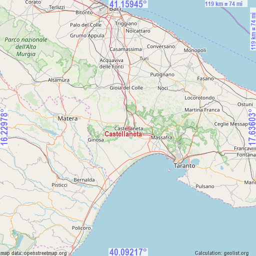
Castellaneta GPS coordinates[2]
40° 37' 40.584" North, 16° 55' 58.44" East
| Map corner | latitude | longitude |
|---|---|---|
| Upper-left | 41.15945°, | 16.22978° |
| Center: | 40.62794°, | 16.9329° |
| Lower-right: | 40.09217°, | 17.63603° |
| Map W x H: | 118.7×118.7 km | = 73.8×73.8mi |
| max Lat: | 47.04031° ⇑83.2% North |
| Castellaneta: | 40.62794° |
| min Lat: | ⇓16.8% South 35.50142° |
| min Long | Castellaneta | max Long |
| 6.69888° | 16.9329° | 18.48682° |
| W 97.9%⇐ | ⇒2.1% E |
Elevation
Elevation of Castellaneta is 218 m = 715 ft, and this is 88.7 m = 291 ft below average elevation for this country.
| Max E: |
2085 m = 6841 ft | 52.7% |
| Avg. | 306.7 m = 1006 ft | |
| Castellaneta | 218 m = 715 ft | |
Min E: |
-4 m = -13 ft | 47.3% |
See also: Italy elevation on elevation.city.
Geographical zone
Castellaneta is located in North temperate zone (between Tropic of Cancer and the Arctic Circle). Distance of this Northern Tropic circle is 1911.5 km =1187.8 mi to South.| Distance of | km | miles | from Castellaneta |
|---|---|---|---|
| North Pole | 5489.7 | 3411.1 | to North |
| Arctic Circle | 2883.8 | 1791.9 | to North |
| Tropic Cancer | 1911.5 | 1187.8 | to South |
| Equator | 4517.4 | 2807 | to South |


Nearby cities:
15 places around Castellaneta: (largest is in red/bold)
• Castellaneta Marina
17.8 km =11.1 mi,  178°
178°
• Ginosa
15.9 km =9.9 mi,  249°
249°
• Gioia del Colle
19.1 km =11.9 mi,  357°
357°
• Laterza
11.3 km =7 mi,  270°
270°
• Lido Azzurro
21.3 km =13.2 mi,  125°
125°
• Marina di Ginosa
22.6 km =14 mi,  191°
191°
• Massafra
16.2 km =10.1 mi,  106°
106°
• Montescaglioso
24.2 km =15 mi, 249°
• Mottola
8.6 km =5.3 mi,  81°
81°
• Noci
24.6 km =15.3 mi,  41°
41°
• Palagianello
4.4 km =2.7 mi,  119°
119°
• Palagiano
10.5 km =6.5 mi, 122°
• Parco di Guerra
19.2 km =11.9 mi, 107°
• Santeramo in Colle
23.4 km =14.5 mi,  321°
321°
• Statte
25.2 km =15.7 mi, 115°
Sources, notices
• [Note1] Compared only with cities in Italy existing in our database
• [Src1] Map data: © OpenStreetMap contributors (CC-BY-SA)
• [Src2] Other city data from geonames.org with taken over terms of usage.
• [Src3] Geographical zone / Annual Mean Temperature by Robert A. Rohde @ Wikipedia
