Paganica-Tempera geodata
Paganica-Tempera (Abruzzo) is a populated place; located in Italy in Europe/Rome (GMT+2) time zone. With population of 4,205 people, there are 2281 cities with bigger population in this country. Compared to other cities in Italy, 67.2% of cities are located further ↑North; 73.2% of cities are located further ←West and 87.1% of cities have lower elevation than Paganica-Tempera. Note1


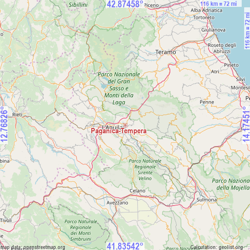
Paganica-Tempera GPS coordinates[2]
42° 21' 25.74" North, 13° 28' 16.968" East
| Map corner | latitude | longitude |
|---|---|---|
| Upper-left | 42.87458°, | 12.76826° |
| Center: | 42.35715°, | 13.47138° |
| Lower-right: | 41.83542°, | 14.17451° |
| Map W x H: | 115.5×115.5 km | = 71.8×71.8mi |
| max Lat: | 47.04031° ⇑67.2% North |
| Paganica-Tempera: | 42.35715° |
| min Lat: | ⇓32.8% South 35.50142° |
| min Long | Paganica-Temper | max Long |
| 6.69888° | 13.47138° | 18.48682° |
| W 73.2%⇐ | ⇒26.8% E |
Elevation
Elevation of Paganica-Tempera is 655 m = 2149 ft, and this is 348.3 m = 1143 ft above average elevation for this country.
| Max E: |
2085 m = 6841 ft | 12.9% |
| Paganica-Tempera | 655 m 2149 ft | |
| Avg. | 306.7 m = 1006 ft | |
Min E: |
-4 m = -13 ft | 87.1% |
See also: Italy elevation on elevation.city.
Geographical zone
Paganica-Tempera is located in North temperate zone (between Tropic of Cancer and the Arctic Circle). Distance of this Northern Tropic circle is 2103.8 km =1307.2 mi to South.| Distance of | km | miles | from Paganica-Tempera |
|---|---|---|---|
| North Pole | 5297.4 | 3291.7 | to North |
| Arctic Circle | 2691.5 | 1672.4 | to North |
| Tropic Cancer | 2103.8 | 1307.2 | to South |
| Equator | 4709.7 | 2926.5 | to South |


Nearby cities:
15 places around Paganica-Tempera: (largest is in red/bold)
• Camarda
4.8 km =3 mi,  28°
28°
• Collebrincioni
6.5 km =4 mi,  314°
314°
• Cominio
5.9 km =3.7 mi,  212°
212°
• Fossa
7.3 km =4.5 mi,  169°
169°
• L'Aquila
5.9 km =3.7 mi,  262°
262°
• Monticchio
4.1 km =2.5 mi,  188°
188°
• Nucleo Industriale di Bazzano
2.3 km =1.4 mi, 187°
• Pianola
6.7 km =4.2 mi,  235°
235°
• Poggio Picenze
7 km =4.3 mi,  125°
125°
• Poggio di Roio
8.2 km =5.1 mi,  249°
249°
• Progetto Case Bazzano
3.2 km =2 mi,  224°
224°
• Roio Piano
9.9 km =6.2 mi, 250°
• San Cipriano
5.6 km =3.5 mi, 243°
• San Panfilo d'Ocre
7.9 km =4.9 mi,  177°
177°
• Sant'Eusanio Forconese
8.7 km =5.4 mi,  149°
149°
Sources, notices
• [Note1] Compared only with cities in Italy existing in our database
• [Src1] Map data: © OpenStreetMap contributors (CC-BY-SA)
• [Src2] Other city data from geonames.org with taken over terms of usage.
• [Src3] Geographical zone / Annual Mean Temperature by Robert A. Rohde @ Wikipedia
