Fossa geodata
Fossa (Abruzzo) is a seat of a third-order administrative division; located in Italy in Europe/Rome (GMT+2) time zone. With population of 546 people, there are 9490 cities with bigger population in this country. Compared to other cities in Italy, 67.8% of cities are located further ↑North; 73.4% of cities are located further ←West and 87.4% of cities have lower elevation than Fossa. Note1


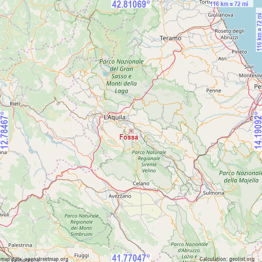
Fossa GPS coordinates[2]
42° 17' 33.828" North, 13° 29' 16.044" East
| Map corner | latitude | longitude |
|---|---|---|
| Upper-left | 42.81069°, | 12.78467° |
| Center: | 42.29273°, | 13.48779° |
| Lower-right: | 41.77047°, | 14.19092° |
| Map W x H: | 115.7×115.7 km | = 71.9×71.9mi |
| max Lat: | 47.04031° ⇑67.8% North |
| Fossa: | 42.29273° |
| min Lat: | ⇓32.2% South 35.50142° |
| min Long | Fossa | max Long |
| 6.69888° | 13.48779° | 18.48682° |
| W 73.4%⇐ | ⇒26.6% E |
Elevation
Elevation of Fossa is 661 m = 2169 ft, and this is 354.3 m = 1162 ft above average elevation for this country.
| Max E: |
2085 m = 6841 ft | 12.6% |
| Fossa | 661 m 2169 ft | |
| Avg. | 306.7 m = 1006 ft | |
Min E: |
-4 m = -13 ft | 87.4% |
See also: Italy elevation on elevation.city.
Geographical zone
Fossa is located in North temperate zone (between Tropic of Cancer and the Arctic Circle). Distance of this Northern Tropic circle is 2096.6 km =1302.8 mi to South.| Distance of | km | miles | from Fossa |
|---|---|---|---|
| North Pole | 5304.6 | 3296.1 | to North |
| Arctic Circle | 2698.7 | 1676.9 | to North |
| Tropic Cancer | 2096.6 | 1302.8 | to South |
| Equator | 4702.5 | 2922 | to South |


Nearby cities:
15 places around Fossa: (largest is in red/bold)
• Barisciano
9.2 km =5.7 mi,  67°
67°
• Cominio
5 km =3.1 mi,  295°
295°
• Monticchio
3.6 km =2.2 mi,  327°
327°
• Nucleo Industriale di Bazzano
5.1 km =3.2 mi,  341°
341°
• Paganica-Tempera
7.3 km =4.5 mi,  349°
349°
• Pianola
7.7 km =4.8 mi, 296°
• Poggio Picenze
5.3 km =3.3 mi,  54°
54°
• Progetto Case Bazzano
6 km =3.7 mi,  323°
323°
• Rocca di Cambio
6.1 km =3.8 mi,  179°
179°
• San Cipriano
7.9 km =4.9 mi,  306°
306°
• San Demetrio Ne' Vestini
5.6 km =3.5 mi,  93°
93°
• San Panfilo d'Ocre
1.3 km =0.8 mi,  234°
234°
• Sant'Eusanio Forconese
3 km =1.9 mi,  96°
96°
• Vallecupa
8.4 km =5.2 mi,  121°
121°
• Villa Sant'Angelo
4.8 km =3 mi, 121°
Sources, notices
• [Note1] Compared only with cities in Italy existing in our database
• [Src1] Map data: © OpenStreetMap contributors (CC-BY-SA)
• [Src2] Other city data from geonames.org with taken over terms of usage.
• [Src3] Geographical zone / Annual Mean Temperature by Robert A. Rohde @ Wikipedia
