Padria geodata
Padria (Sardinia) is a seat of a third-order administrative division; located in Italy in Europe/Rome (GMT+2) time zone. With population of 692 people, there are 8356 cities with bigger population in this country. Compared to other cities in Italy, 84.8% of cities are located further ↑North; 86.4% of cities are located further →East and 60.9% of cities have lower elevation than Padria. Note1


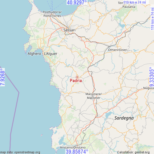
Padria GPS coordinates[2]
40° 23' 46.86" North, 8° 37' 47.712" East
| Map corner | latitude | longitude |
|---|---|---|
| Upper-left | 40.9297°, | 7.9268° |
| Center: | 40.39635°, | 8.62992° |
| Lower-right: | 39.85874°, | 9.33305° |
| Map W x H: | 119.1×119.1 km | = 74×74mi |
| max Lat: | 47.04031° ⇑84.8% North |
| Padria: | 40.39635° |
| min Lat: | ⇓15.2% South 35.50142° |
| min Long | Padria | max Long |
| 6.69888° | 8.62992° | 18.48682° |
| W 13.6%⇐ | ⇒86.4% E |
Elevation
Elevation of Padria is 306 m = 1004 ft, and this is 0.69999999999999 m = 2 ft below average elevation for this country.
| Max E: |
2085 m = 6841 ft | 39.1% |
| Avg. | 306.7 m = 1006 ft | |
| Padria | 306 m = 1004 ft | |
Min E: |
-4 m = -13 ft | 60.9% |
See also: Italy elevation on elevation.city.
Geographical zone
Padria is located in North temperate zone (between Tropic of Cancer and the Arctic Circle). Distance of this Northern Tropic circle is 1885.7 km =1171.7 mi to South.| Distance of | km | miles | from Padria |
|---|---|---|---|
| North Pole | 5515.4 | 3427.1 | to North |
| Arctic Circle | 2909.5 | 1807.9 | to North |
| Tropic Cancer | 1885.7 | 1171.7 | to South |
| Equator | 4491.7 | 2791 | to South |


Nearby cities:
15 places around Padria: (largest is in red/bold)
• Bonorva
12 km =7.5 mi,  78°
78°
• Bosa
15.5 km =9.6 mi,  225°
225°
• Cheremule
14.5 km =9 mi,  33°
33°
• Cossoine
8.2 km =5.1 mi,  62°
62°
• Giave
12 km =7.5 mi, 58°
• Mara
1.6 km =1 mi,  20°
20°
• Monteleone Rocca Doria
10.3 km =6.4 mi,  325°
325°
• Montresta
11.3 km =7 mi,  257°
257°
• Pozzomaggiore
2.5 km =1.6 mi,  86°
86°
• Romana
10.5 km =6.5 mi,  339°
339°
• Sagama
15.6 km =9.7 mi,  196°
196°
• Semestene
8.1 km =5 mi, 88°
• Sindia
11.5 km =7.1 mi,  168°
168°
• Suni
14.5 km =9 mi,  207°
207°
• Tinnura
15.7 km =9.8 mi, 206°
Sources, notices
• [Note1] Compared only with cities in Italy existing in our database
• [Src1] Map data: © OpenStreetMap contributors (CC-BY-SA)
• [Src2] Other city data from geonames.org with taken over terms of usage.
• [Src3] Geographical zone / Annual Mean Temperature by Robert A. Rohde @ Wikipedia
