Tinnura geodata
Tinnura (Sardinia) is a seat of a third-order administrative division; located in Italy in Europe/Rome (GMT+2) time zone. With population of 268 people, there are 10809 cities with bigger population in this country. Compared to other cities in Italy, 85.9% of cities are located further ↑North; 87.4% of cities are located further →East and 63.7% of cities have lower elevation than Tinnura. Note1


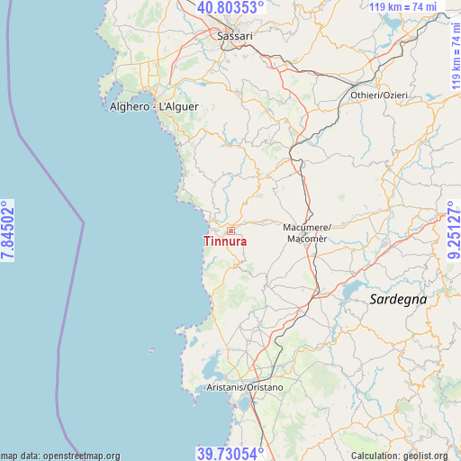
Tinnura GPS coordinates[2]
40° 16' 8.976" North, 8° 32' 53.34" East
| Map corner | latitude | longitude |
|---|---|---|
| Upper-left | 40.80353°, | 7.84502° |
| Center: | 40.26916°, | 8.54815° |
| Lower-right: | 39.73054°, | 9.25127° |
| Map W x H: | 119.3×119.3 km | = 74.1×74.1mi |
| max Lat: | 47.04031° ⇑85.9% North |
| Tinnura: | 40.26916° |
| min Lat: | ⇓14.1% South 35.50142° |
| min Long | Tinnura | max Long |
| 6.69888° | 8.54815° | 18.48682° |
| W 12.6%⇐ | ⇒87.4% E |
Elevation
Elevation of Tinnura is 330 m = 1083 ft, and this is 23.3 m = 76 ft above average elevation for this country.
| Max E: |
2085 m = 6841 ft | 36.3% |
| Tinnura | 330 m 1083 ft | |
| Avg. | 306.7 m = 1006 ft | |
Min E: |
-4 m = -13 ft | 63.7% |
See also: Italy elevation on elevation.city.
Geographical zone
Tinnura is located in North temperate zone (between Tropic of Cancer and the Arctic Circle). Distance of this Northern Tropic circle is 1871.6 km =1163 mi to South.| Distance of | km | miles | from Tinnura |
|---|---|---|---|
| North Pole | 5529.6 | 3435.9 | to North |
| Arctic Circle | 2923.7 | 1816.7 | to North |
| Tropic Cancer | 1871.6 | 1163 | to South |
| Equator | 4477.5 | 2782.2 | to South |


Nearby cities:
15 places around Tinnura: (largest is in red/bold)
• Bosa
5.4 km =3.4 mi,  308°
308°
• Cuglieri
9.2 km =5.7 mi,  169°
169°
• Flussio
0.9 km =0.6 mi,  244°
244°
• Magomadas
2.2 km =1.4 mi,  252°
252°
• Modolo
1.7 km =1.1 mi,  294°
294°
• Montresta
12.3 km =7.6 mi,  340°
340°
• Padria
15.7 km =9.8 mi,  26°
26°
• Pozzomaggiore
17.1 km =10.6 mi, 33°
• Sagama
2.6 km =1.6 mi,  108°
108°
• Santu Lussurgiu
16.9 km =10.5 mi,  147°
147°
• Scano di Montiferro
6.8 km =4.2 mi, 151°
• Sennariolo
6.3 km =3.9 mi, 174°
• Sindia
9.7 km =6 mi,  72°
72°
• Suni
1.3 km =0.8 mi,  4°
4°
• Tresnuraghes
3 km =1.9 mi,  231°
231°
Sources, notices
• [Note1] Compared only with cities in Italy existing in our database
• [Src1] Map data: © OpenStreetMap contributors (CC-BY-SA)
• [Src2] Other city data from geonames.org with taken over terms of usage.
• [Src3] Geographical zone / Annual Mean Temperature by Robert A. Rohde @ Wikipedia
