Otranto geodata
Otranto (Apulia) is a seat of a third-order administrative division; located in Italy in Europe/Rome (GMT+2) time zone. With population of 4,914 people, there are 1984 cities with bigger population in this country. Compared to other cities in Italy, 86.8% of cities are located further ↑North; 100% of cities are located further ←West and 97.2% of cities have higher elevation than Otranto. Note1


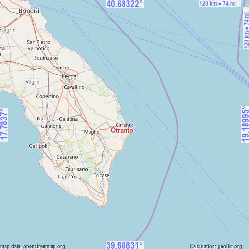
Otranto GPS coordinates[2]
40° 8' 52.404" North, 18° 29' 12.552" East
| Map corner | latitude | longitude |
|---|---|---|
| Upper-left | 40.68322°, | 17.7837° |
| Center: | 40.14789°, | 18.48682° |
| Lower-right: | 39.60831°, | 19.18995° |
| Map W x H: | 119.5×119.5 km | = 74.3×74.3mi |
| max Lat: | 47.04031° ⇑86.8% North |
| Otranto: | 40.14789° |
| min Lat: | ⇓13.2% South 35.50142° |
| min Long | Otranto | max Long |
| 6.69888° | 18.48682° | 18.48682° |
| W 100%⇐ | ⇒0% E |
Elevation
Elevation of Otranto is 5 m = 16 ft, and this is 301.7 m = 990 ft below average elevation for this country.
| Max E: |
2085 m = 6841 ft | 97.2% |
| Avg. | 306.7 m = 1006 ft | |
| Otranto | 5 m = 16 ft | |
Min E: |
-4 m = -13 ft | 2.8% |
See also: Italy elevation on elevation.city.
Geographical zone
Otranto is located in North temperate zone (between Tropic of Cancer and the Arctic Circle). Distance of this Northern Tropic circle is 1858.1 km =1154.6 mi to South.| Distance of | km | miles | from Otranto |
|---|---|---|---|
| North Pole | 5543 | 3444.3 | to North |
| Arctic Circle | 2937.1 | 1825 | to North |
| Tropic Cancer | 1858.1 | 1154.6 | to South |
| Equator | 4464 | 2773.8 | to South |


Nearby cities:
15 places around Otranto: (largest is in red/bold)
• Bagnolo del Salento
11.5 km =7.1 mi,  270°
270°
• Cannole
10.6 km =6.6 mi,  280°
280°
• Casamassella
4.8 km =3 mi,  219°
219°
• Cerfignano
10.4 km =6.5 mi,  201°
201°
• Cocumola
10.3 km =6.4 mi,  207°
207°
• Giuggianello
11.7 km =7.3 mi,  239°
239°
• Giurdignano
5.4 km =3.4 mi, 240°
• Minervino di Lecce
8.5 km =5.3 mi, 220°
• Muro Leccese
13.7 km =8.5 mi,  248°
248°
• Palmariggi
9.4 km =5.8 mi,  258°
258°
• Sanarica
13.5 km =8.4 mi, 241°
• Santa Cesarea Terme
12.7 km =7.9 mi,  192°
192°
• Serrano
12.2 km =7.6 mi,  289°
289°
• Uggiano la Chiesa
6.1 km =3.8 mi, 211°
• Vitigliano
13.6 km =8.5 mi, 207°
Sources, notices
• [Note1] Compared only with cities in Italy existing in our database
• [Src1] Map data: © OpenStreetMap contributors (CC-BY-SA)
• [Src2] Other city data from geonames.org with taken over terms of usage.
• [Src3] Geographical zone / Annual Mean Temperature by Robert A. Rohde @ Wikipedia
