Cerfignano geodata
Cerfignano (Apulia) is a populated place; located in Italy in Europe/Rome (GMT+2) time zone. With population of 1,570 people, there are 4958 cities with bigger population in this country. Compared to other cities in Italy, 87.5% of cities are located further ↑North; 100% of cities are located further ←West and 69.6% of cities have higher elevation than Cerfignano. Note1
Administrative division(s):
- Level 1: Apulia
- Level 2: Provincia di Lecce
- Level 3: Santa Cesarea Terme


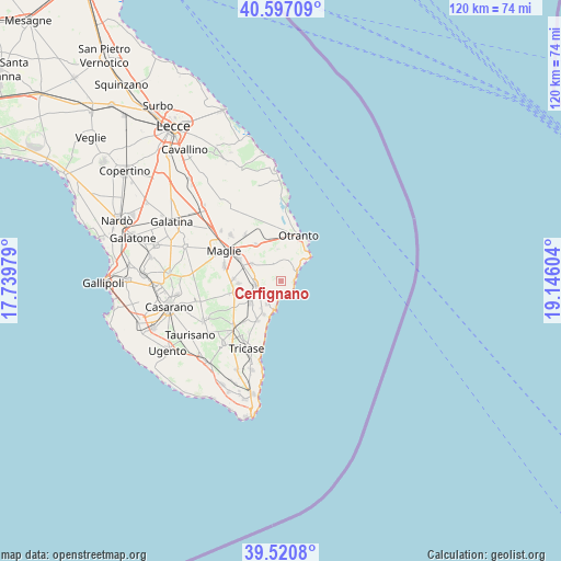
Cerfignano GPS coordinates[2]
40° 3' 39.852" North, 18° 26' 34.476" East
| Map corner | latitude | longitude |
|---|---|---|
| Upper-left | 40.59709°, | 17.73979° |
| Center: | 40.06107°, | 18.44291° |
| Lower-right: | 39.5208°, | 19.14604° |
| Map W x H: | 119.7×119.7 km | = 74.4×74.4mi |
| max Lat: | 47.04031° ⇑87.5% North |
| Cerfignano: | 40.06107° |
| min Lat: | ⇓12.5% South 35.50142° |
| min Long | Cerfignano | max Long |
| 6.69888° | 18.44291° | 18.48682° |
| W 100%⇐ | ⇒0% E |
Elevation
Elevation of Cerfignano is 100 m = 328 ft, and this is 206.7 m = 678 ft below average elevation for this country.
| Max E: |
2085 m = 6841 ft | 69.6% |
| Avg. | 306.7 m = 1006 ft | |
| Cerfignano | 100 m = 328 ft | |
Min E: |
-4 m = -13 ft | 30.4% |
See also: Italy elevation on elevation.city.
Geographical zone
Cerfignano is located in North temperate zone (between Tropic of Cancer and the Arctic Circle). Distance of this Northern Tropic circle is 1848.5 km =1148.6 mi to South.| Distance of | km | miles | from Cerfignano |
|---|---|---|---|
| North Pole | 5552.7 | 3450.3 | to North |
| Arctic Circle | 2946.8 | 1831.1 | to North |
| Tropic Cancer | 1848.5 | 1148.6 | to South |
| Equator | 4454.4 | 2767.8 | to South |


Nearby cities:
15 places around Cerfignano: (largest is in red/bold)
• Casamassella
6 km =3.7 mi,  6°
6°
• Castro
6.2 km =3.9 mi,  193°
193°
• Cocumola
1.2 km =0.7 mi,  297°
297°
• Diso
7.2 km =4.5 mi,  217°
217°
• Giuggianello
7.3 km =4.5 mi, 300°
• Giurdignano
7 km =4.3 mi,  352°
352°
• Marittima
8.1 km =5 mi,  207°
207°
• Minervino di Lecce
3.7 km =2.3 mi,  330°
330°
• Ortelle
5.3 km =3.3 mi,  235°
235°
• Poggiardo
5.6 km =3.5 mi,  260°
260°
• Santa Cesarea Terme
3 km =1.9 mi,  159°
159°
• Spongano
8.1 km =5 mi,  233°
233°
• Uggiano la Chiesa
4.5 km =2.8 mi, 6°
• Vignacastrisi
5.9 km =3.7 mi, 211°
• Vitigliano
3.6 km =2.2 mi, 227°
Sources, notices
• [Note1] Compared only with cities in Italy existing in our database
• [Src1] Map data: © OpenStreetMap contributors (CC-BY-SA)
• [Src2] Other city data from geonames.org with taken over terms of usage.
• [Src3] Geographical zone / Annual Mean Temperature by Robert A. Rohde @ Wikipedia
