Orte geodata
Orte (Latium) is a seat of a third-order administrative division; located in Italy in Europe/Rome (GMT+2) time zone. With population of 3,865 people, there are 2473 cities with bigger population in this country. Compared to other cities in Italy, 66.5% of cities are located further ↑North; 61.1% of cities are located further ←West and 64.3% of cities have higher elevation than Orte. Note1


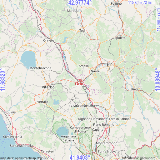
Orte GPS coordinates[2]
42° 27' 40.212" North, 12° 23' 10.86" East
| Map corner | latitude | longitude |
|---|---|---|
| Upper-left | 42.97774°, | 11.68323° |
| Center: | 42.46117°, | 12.38635° |
| Lower-right: | 41.9403°, | 13.08948° |
| Map W x H: | 115.4×115.4 km | = 71.7×71.7mi |
| max Lat: | 47.04031° ⇑66.5% North |
| Orte: | 42.46117° |
| min Lat: | ⇓33.5% South 35.50142° |
| min Long | Orte | max Long |
| 6.69888° | 12.38635° | 18.48682° |
| W 61.1%⇐ | ⇒38.9% E |
Elevation
Elevation of Orte is 132 m = 433 ft, and this is 174.7 m = 573 ft below average elevation for this country.
| Max E: |
2085 m = 6841 ft | 64.3% |
| Avg. | 306.7 m = 1006 ft | |
| Orte | 132 m = 433 ft | |
Min E: |
-4 m = -13 ft | 35.7% |
See also: Italy elevation on elevation.city.
Geographical zone
Orte is located in North temperate zone (between Tropic of Cancer and the Arctic Circle). Distance of this Northern Tropic circle is 2115.3 km =1314.4 mi to South.| Distance of | km | miles | from Orte |
|---|---|---|---|
| North Pole | 5285.8 | 3284.4 | to North |
| Arctic Circle | 2679.9 | 1665.2 | to North |
| Tropic Cancer | 2115.3 | 1314.4 | to South |
| Equator | 4721.2 | 2933.6 | to South |


Nearby cities:
15 places around Orte: (largest is in red/bold)
• Amelia
10.5 km =6.5 mi,  15°
15°
• Attigliano
9.6 km =6 mi,  308°
308°
• Bassano in Teverina
6.5 km =4 mi,  273°
273°
• Bomarzo
11.4 km =7.1 mi,  282°
282°
• Fornole
10.7 km =6.6 mi,  32°
32°
• Gallese
9.8 km =6.1 mi,  175°
175°
• Giove
7.1 km =4.4 mi,  319°
319°
• Orte Scalo
3.4 km =2.1 mi,  148°
148°
• Otricoli
8.7 km =5.4 mi,  121°
121°
• Penna in Teverina
4.3 km =2.7 mi,  327°
327°
• San Liberato
5 km =3.1 mi,  64°
64°
• Scalo Teverina
10.6 km =6.6 mi, 153°
• Testaccio
11.8 km =7.3 mi,  70°
70°
• Vasanello
6 km =3.7 mi,  211°
211°
• Vignanello
12.7 km =7.9 mi,  224°
224°
Sources, notices
• [Note1] Compared only with cities in Italy existing in our database
• [Src1] Map data: © OpenStreetMap contributors (CC-BY-SA)
• [Src2] Other city data from geonames.org with taken over terms of usage.
• [Src3] Geographical zone / Annual Mean Temperature by Robert A. Rohde @ Wikipedia
