Giove geodata
Giove (Umbria) is a seat of a third-order administrative division; located in Italy in Europe/Rome (GMT+2) time zone. With population of 1,238 people, there are 5836 cities with bigger population in this country. Compared to other cities in Italy, 66.3% of cities are located further ↑North; 60.3% of cities are located further ←West and 59.5% of cities have lower elevation than Giove. Note1


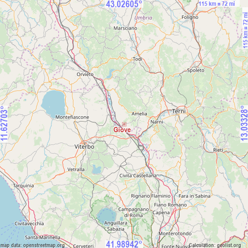
Giove GPS coordinates[2]
42° 30' 35.568" North, 12° 19' 48.54" East
| Map corner | latitude | longitude |
|---|---|---|
| Upper-left | 43.02605°, | 11.62703° |
| Center: | 42.50988°, | 12.33015° |
| Lower-right: | 41.98942°, | 13.03328° |
| Map W x H: | 115.3×115.3 km | = 71.6×71.6mi |
| max Lat: | 47.04031° ⇑66.3% North |
| Giove: | 42.50988° |
| min Lat: | ⇓33.7% South 35.50142° |
| min Long | Giove | max Long |
| 6.69888° | 12.33015° | 18.48682° |
| W 60.3%⇐ | ⇒39.7% E |
Elevation
Elevation of Giove is 296 m = 971 ft, and this is 10.7 m = 35 ft below average elevation for this country.
| Max E: |
2085 m = 6841 ft | 40.5% |
| Avg. | 306.7 m = 1006 ft | |
| Giove | 296 m = 971 ft | |
Min E: |
-4 m = -13 ft | 59.5% |
See also: Italy elevation on elevation.city.
Geographical zone
Giove is located in North temperate zone (between Tropic of Cancer and the Arctic Circle). Distance of this Northern Tropic circle is 2120.7 km =1317.7 mi to South.| Distance of | km | miles | from Giove |
|---|---|---|---|
| North Pole | 5280.4 | 3281.1 | to North |
| Arctic Circle | 2674.5 | 1661.9 | to North |
| Tropic Cancer | 2120.7 | 1317.7 | to South |
| Equator | 4726.7 | 2937 | to South |


Nearby cities:
15 places around Giove: (largest is in red/bold)
• Alviano
9.4 km =5.8 mi,  343°
343°
• Amelia
8.8 km =5.5 mi,  57°
57°
• Attigliano
3 km =1.9 mi,  281°
281°
• Bassano in Teverina
5.4 km =3.4 mi,  200°
200°
• Bomarzo
7.2 km =4.5 mi,  245°
245°
• Fornole
10.9 km =6.8 mi,  70°
70°
• Graffignano
12.8 km =8 mi,  304°
304°
• Lugnano in Teverina
7.3 km =4.5 mi,  2°
2°
• Orte
7.1 km =4.4 mi,  139°
139°
• Orte Scalo
10.5 km =6.5 mi, 142°
• Penna in Teverina
3 km =1.9 mi,  128°
128°
• San Liberato
9.7 km =6 mi,  109°
109°
• Sipicciano
9.2 km =5.7 mi,  294°
294°
• Soriano nel Cimino
12.9 km =8 mi,  217°
217°
• Vasanello
10.6 km =6.6 mi,  172°
172°
Sources, notices
• [Note1] Compared only with cities in Italy existing in our database
• [Src1] Map data: © OpenStreetMap contributors (CC-BY-SA)
• [Src2] Other city data from geonames.org with taken over terms of usage.
• [Src3] Geographical zone / Annual Mean Temperature by Robert A. Rohde @ Wikipedia
