Testaccio geodata
Testaccio (Umbria) is a populated place; located in Italy in Europe/Rome (GMT+2) time zone. With population of 562 people, there are 9332 cities with bigger population in this country. Compared to other cities in Italy, 66.3% of cities are located further ↑North; 62.6% of cities are located further ←West and 52.5% of cities have lower elevation than Testaccio. Note1


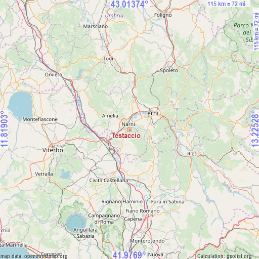
Testaccio GPS coordinates[2]
42° 29' 50.892" North, 12° 31' 19.74" East
| Map corner | latitude | longitude |
|---|---|---|
| Upper-left | 43.01374°, | 11.81903° |
| Center: | 42.49747°, | 12.52215° |
| Lower-right: | 41.9769°, | 13.22528° |
| Map W x H: | 115.3×115.3 km | = 71.6×71.6mi |
| max Lat: | 47.04031° ⇑66.3% North |
| Testaccio: | 42.49747° |
| min Lat: | ⇓33.7% South 35.50142° |
| min Long | Testaccio | max Long |
| 6.69888° | 12.52215° | 18.48682° |
| W 62.6%⇐ | ⇒37.4% E |
Elevation
Elevation of Testaccio is 250 m = 820 ft, and this is 56.7 m = 186 ft below average elevation for this country.
| Max E: |
2085 m = 6841 ft | 47.5% |
| Avg. | 306.7 m = 1006 ft | |
| Testaccio | 250 m = 820 ft | |
Min E: |
-4 m = -13 ft | 52.5% |
See also: Italy elevation on elevation.city.
Geographical zone
Testaccio is located in North temperate zone (between Tropic of Cancer and the Arctic Circle). Distance of this Northern Tropic circle is 2119.4 km =1316.9 mi to South.| Distance of | km | miles | from Testaccio |
|---|---|---|---|
| North Pole | 5281.8 | 3282 | to North |
| Arctic Circle | 2675.9 | 1662.7 | to North |
| Tropic Cancer | 2119.4 | 1316.9 | to South |
| Equator | 4725.3 | 2936.2 | to South |


Nearby cities:
15 places around Testaccio: (largest is in red/bold)
• Amelia
10.3 km =6.4 mi,  306°
306°
• Calvi dell'Umbria
11 km =6.8 mi,  160°
160°
• Configni
12.8 km =8 mi,  128°
128°
• Fornole
7.4 km =4.6 mi, 312°
• Narni
2.5 km =1.6 mi,  10°
10°
• Narni Scalo
4.3 km =2.7 mi,  354°
354°
• Orte
11.8 km =7.3 mi,  250°
250°
• Orte Scalo
11.7 km =7.3 mi,  233°
233°
• Otricoli
9.3 km =5.8 mi,  203°
203°
• Ponte San Lorenzo
6.3 km =3.9 mi,  47°
47°
• Roman catholic diocese of Terni
12.2 km =7.6 mi, 54°
• San Gemini
13.1 km =8.1 mi, 8°
• San Liberato
6.9 km =4.3 mi, 254°
• Stroncone
10.4 km =6.5 mi,  81°
81°
• Terni
12.3 km =7.6 mi, 53°
Sources, notices
• [Note1] Compared only with cities in Italy existing in our database
• [Src1] Map data: © OpenStreetMap contributors (CC-BY-SA)
• [Src2] Other city data from geonames.org with taken over terms of usage.
• [Src3] Geographical zone / Annual Mean Temperature by Robert A. Rohde @ Wikipedia
