Fornole geodata
Fornole (Umbria) is a populated place; located in Italy in Europe/Rome (GMT+2) time zone. With population of 1,308 people, there are 5610 cities with bigger population in this country. Compared to other cities in Italy, 66% of cities are located further ↑North; 61.9% of cities are located further ←West and 63.8% of cities have lower elevation than Fornole. Note1


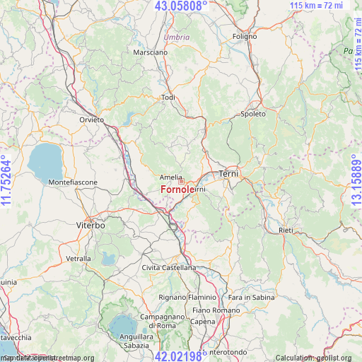
Fornole GPS coordinates[2]
42° 32' 31.848" North, 12° 27' 20.736" East
| Map corner | latitude | longitude |
|---|---|---|
| Upper-left | 43.05808°, | 11.75264° |
| Center: | 42.54218°, | 12.45576° |
| Lower-right: | 42.02198°, | 13.15889° |
| Map W x H: | 115.2×115.2 km | = 71.6×71.6mi |
| max Lat: | 47.04031° ⇑66% North |
| Fornole: | 42.54218° |
| min Lat: | ⇓34% South 35.50142° |
| min Long | Fornole | max Long |
| 6.69888° | 12.45576° | 18.48682° |
| W 61.9%⇐ | ⇒38.1% E |
Elevation
Elevation of Fornole is 332 m = 1089 ft, and this is 25.3 m = 83 ft above average elevation for this country.
| Max E: |
2085 m = 6841 ft | 36.2% |
| Fornole | 332 m 1089 ft | |
| Avg. | 306.7 m = 1006 ft | |
Min E: |
-4 m = -13 ft | 63.8% |
See also: Italy elevation on elevation.city.
Geographical zone
Fornole is located in North temperate zone (between Tropic of Cancer and the Arctic Circle). Distance of this Northern Tropic circle is 2124.3 km =1320 mi to South.| Distance of | km | miles | from Fornole |
|---|---|---|---|
| North Pole | 5276.8 | 3278.9 | to North |
| Arctic Circle | 2670.9 | 1659.6 | to North |
| Tropic Cancer | 2124.3 | 1320 | to South |
| Equator | 4730.2 | 2939.2 | to South |


Nearby cities:
15 places around Fornole: (largest is in red/bold)
• Amelia
3.1 km =1.9 mi,  290°
290°
• Avigliano Umbro
12.6 km =7.8 mi,  348°
348°
• Castel dell'Aquila
11.2 km =7 mi,  338°
338°
• Giove
10.9 km =6.8 mi,  250°
250°
• Lugnano in Teverina
10.7 km =6.6 mi, 290°
• Montecastrilli
12.4 km =7.7 mi,  12°
12°
• Narni
6.4 km =4 mi,  113°
113°
• Narni Scalo
5 km =3.1 mi,  97°
97°
• Orte
10.7 km =6.6 mi,  212°
212°
• Orte Scalo
12.6 km =7.8 mi,  198°
198°
• Penna in Teverina
9.6 km =6 mi,  235°
235°
• Ponte San Lorenzo
10.2 km =6.3 mi,  94°
94°
• San Gemini
10.8 km =6.7 mi,  42°
42°
• San Liberato
6.9 km =4.3 mi,  189°
189°
• Testaccio
7.4 km =4.6 mi,  132°
132°
Sources, notices
• [Note1] Compared only with cities in Italy existing in our database
• [Src1] Map data: © OpenStreetMap contributors (CC-BY-SA)
• [Src2] Other city data from geonames.org with taken over terms of usage.
• [Src3] Geographical zone / Annual Mean Temperature by Robert A. Rohde @ Wikipedia
