Oggiono geodata
Oggiono (Lombardy) is a seat of a third-order administrative division; located in Italy in Europe/Rome (GMT+2) time zone. With population of 8,177 people, there are 1182 cities with bigger population in this country. Compared to other cities in Italy, 85.4% of cities are located further ↓South; 75.5% of cities are located further →East and 56.6% of cities have lower elevation than Oggiono. Note1


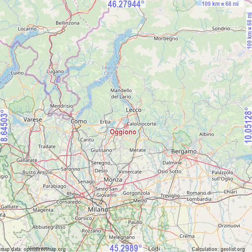
Oggiono GPS coordinates[2]
45° 47' 28.788" North, 9° 20' 53.34" East
| Map corner | latitude | longitude |
|---|---|---|
| Upper-left | 46.27944°, | 8.64503° |
| Center: | 45.79133°, | 9.34815° |
| Lower-right: | 45.2989°, | 10.05128° |
| Map W x H: | 109×109 km | = 67.7×67.7mi |
| max Lat: | 47.04031° ⇑14.6% North |
| Oggiono: | 45.79133° |
| min Lat: | ⇓85.4% South 35.50142° |
| min Long | Oggiono | max Long |
| 6.69888° | 9.34815° | 18.48682° |
| W 24.5%⇐ | ⇒75.5% E |
Elevation
Elevation of Oggiono is 276 m = 906 ft, and this is 30.7 m = 101 ft below average elevation for this country.
| Max E: |
2085 m = 6841 ft | 43.4% |
| Avg. | 306.7 m = 1006 ft | |
| Oggiono | 276 m = 906 ft | |
Min E: |
-4 m = -13 ft | 56.6% |
See also: Italy elevation on elevation.city.
Geographical zone
Oggiono is located in North temperate zone (between Tropic of Cancer and the Arctic Circle). Distance of this North polar circle is 2309.7 km =1435.2 mi to North.| Distance of | km | miles | from Oggiono |
|---|---|---|---|
| North Pole | 4915.5 | 3054.3 | to North |
| Arctic Circle | 2309.7 | 1435.2 | to North |
| Tropic Cancer | 2485.6 | 1544.5 | to South |
| Equator | 5091.5 | 3163.7 | to South |


Nearby cities:
15 places around Oggiono: (largest is in red/bold)
• Annone di Brianza
1.8 km =1.1 mi,  312°
312°
• Brongio
4 km =2.5 mi,  223°
223°
• Case Manzoni-Pascolo-Coroldo
3.2 km =2 mi,  264°
264°
• Castello di Brianza
3.6 km =2.2 mi,  183°
183°
• Colle Brianza
3.5 km =2.2 mi,  158°
158°
• Cologna-Caraverio
3.9 km =2.4 mi, 182°
• Dolzago
2.8 km =1.7 mi,  194°
194°
• Ello
1.5 km =0.9 mi,  115°
115°
• Galbiate
3.7 km =2.3 mi,  40°
40°
• Molteno
3.7 km =2.3 mi,  246°
246°
• Nava
3.4 km =2.1 mi, 160°
• Sala al Barro
3.4 km =2.1 mi,  18°
18°
• Sirone
2.9 km =1.8 mi, 224°
• Suello
4 km =2.5 mi, 314°
• Vergano-Villa
2.1 km =1.3 mi,  81°
81°
Sources, notices
• [Note1] Compared only with cities in Italy existing in our database
• [Src1] Map data: © OpenStreetMap contributors (CC-BY-SA)
• [Src2] Other city data from geonames.org with taken over terms of usage.
• [Src3] Geographical zone / Annual Mean Temperature by Robert A. Rohde @ Wikipedia
