Galbiate geodata
Galbiate (Lombardy) is a seat of a third-order administrative division; located in Italy in Europe/Rome (GMT+2) time zone. With population of 4,513 people, there are 2142 cities with bigger population in this country. Compared to other cities in Italy, 86.5% of cities are located further ↓South; 74.9% of cities are located further →East and 66.9% of cities have lower elevation than Galbiate. Note1


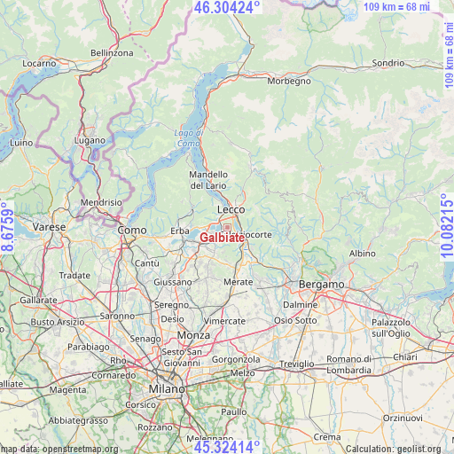
Galbiate GPS coordinates[2]
45° 48' 58.86" North, 9° 22' 44.472" East
| Map corner | latitude | longitude |
|---|---|---|
| Upper-left | 46.30424°, | 8.6759° |
| Center: | 45.81635°, | 9.37902° |
| Lower-right: | 45.32414°, | 10.08215° |
| Map W x H: | 109×109 km | = 67.7×67.7mi |
| max Lat: | 47.04031° ⇑13.5% North |
| Galbiate: | 45.81635° |
| min Lat: | ⇓86.5% South 35.50142° |
| min Long | Galbiate | max Long |
| 6.69888° | 9.37902° | 18.48682° |
| W 25.1%⇐ | ⇒74.9% E |
Elevation
Elevation of Galbiate is 362 m = 1188 ft, and this is 55.3 m = 181 ft above average elevation for this country.
| Max E: |
2085 m = 6841 ft | 33.1% |
| Galbiate | 362 m 1188 ft | |
| Avg. | 306.7 m = 1006 ft | |
Min E: |
-4 m = -13 ft | 66.9% |
See also: Italy elevation on elevation.city.
Geographical zone
Galbiate is located in North temperate zone (between Tropic of Cancer and the Arctic Circle). Distance of this North polar circle is 2306.9 km =1433.4 mi to North.| Distance of | km | miles | from Galbiate |
|---|---|---|---|
| North Pole | 4912.8 | 3052.7 | to North |
| Arctic Circle | 2306.9 | 1433.4 | to North |
| Tropic Cancer | 2488.4 | 1546.2 | to South |
| Equator | 5094.3 | 3165.5 | to South |


Nearby cities:
15 places around Galbiate: (largest is in red/bold)
• Annone di Brianza
4 km =2.5 mi,  246°
246°
• Calolziocorte
5.1 km =3.2 mi,  117°
117°
• Civate
3.1 km =1.9 mi,  295°
295°
• Ello
3.6 km =2.2 mi,  197°
197°
• Garlate
1.7 km =1.1 mi,  106°
106°
• Lecco
4.6 km =2.9 mi,  17°
17°
• Malgrate
3.6 km =2.2 mi,  356°
356°
• Oggiono
3.7 km =2.3 mi,  220°
220°
• Olginate
4.2 km =2.6 mi,  132°
132°
• Pescate
2.2 km =1.4 mi,  31°
31°
• Sala al Barro
1.4 km =0.9 mi,  289°
289°
• Valgreghentino
4.9 km =3 mi,  147°
147°
• Valmadrera-Caserta
3.7 km =2.3 mi,  334°
334°
• Vercurago
3.4 km =2.1 mi,  102°
102°
• Vergano-Villa
2.5 km =1.6 mi,  187°
187°
Sources, notices
• [Note1] Compared only with cities in Italy existing in our database
• [Src1] Map data: © OpenStreetMap contributors (CC-BY-SA)
• [Src2] Other city data from geonames.org with taken over terms of usage.
• [Src3] Geographical zone / Annual Mean Temperature by Robert A. Rohde @ Wikipedia
