Molteno geodata
Molteno (Lombardy) is a seat of a third-order administrative division; located in Italy in Europe/Rome (GMT+2) time zone. With population of 2,518 people, there are 3502 cities with bigger population in this country. Compared to other cities in Italy, 84.8% of cities are located further ↓South; 76.3% of cities are located further →East and 55.9% of cities have lower elevation than Molteno. Note1


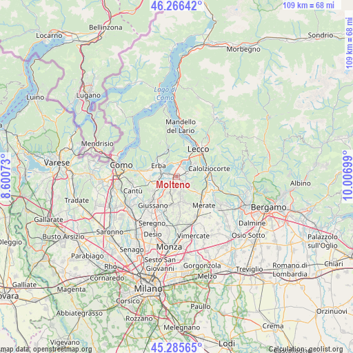
Molteno GPS coordinates[2]
45° 46' 41.484" North, 9° 18' 13.896" East
| Map corner | latitude | longitude |
|---|---|---|
| Upper-left | 46.26642°, | 8.60073° |
| Center: | 45.77819°, | 9.30386° |
| Lower-right: | 45.28565°, | 10.00699° |
| Map W x H: | 109.1×109.1 km | = 67.8×67.8mi |
| max Lat: | 47.04031° ⇑15.2% North |
| Molteno: | 45.77819° |
| min Lat: | ⇓84.8% South 35.50142° |
| min Long | Molteno | max Long |
| 6.69888° | 9.30386° | 18.48682° |
| W 23.7%⇐ | ⇒76.3% E |
Elevation
Elevation of Molteno is 271 m = 889 ft, and this is 35.7 m = 117 ft below average elevation for this country.
| Max E: |
2085 m = 6841 ft | 44.1% |
| Avg. | 306.7 m = 1006 ft | |
| Molteno | 271 m = 889 ft | |
Min E: |
-4 m = -13 ft | 55.9% |
See also: Italy elevation on elevation.city.
Geographical zone
Molteno is located in North temperate zone (between Tropic of Cancer and the Arctic Circle). Distance of this North polar circle is 2311.1 km =1436.1 mi to North.| Distance of | km | miles | from Molteno |
|---|---|---|---|
| North Pole | 4917 | 3055.3 | to North |
| Arctic Circle | 2311.1 | 1436.1 | to North |
| Tropic Cancer | 2484.1 | 1543.5 | to South |
| Equator | 5090.1 | 3162.8 | to South |


Nearby cities:
15 places around Molteno: (largest is in red/bold)
• Annone di Brianza
3.4 km =2.1 mi,  38°
38°
• Barzago
2.7 km =1.7 mi,  162°
162°
• Bosisio Parini
2.7 km =1.7 mi,  336°
336°
• Brongio
1.6 km =1 mi,  154°
154°
• Bulciago
3.4 km =2.1 mi,  205°
205°
• Case Manzoni-Pascolo-Coroldo
1.2 km =0.7 mi,  11°
11°
• Castello di Brianza
3.8 km =2.4 mi,  123°
123°
• Costa Masnaga
2.3 km =1.4 mi,  245°
245°
• Dolzago
3 km =1.9 mi,  114°
114°
• Garbagnate
1 km =0.6 mi, 205°
• Garbagnate Monastero
0.6 km =0.4 mi,  199°
199°
• Oggiono
3.7 km =2.3 mi,  66°
66°
• Rogeno
2.4 km =1.5 mi,  281°
281°
• Sirone
1.5 km =0.9 mi, 113°
• Tabiago-Cibrone
3.8 km =2.4 mi,  229°
229°
Sources, notices
• [Note1] Compared only with cities in Italy existing in our database
• [Src1] Map data: © OpenStreetMap contributors (CC-BY-SA)
• [Src2] Other city data from geonames.org with taken over terms of usage.
• [Src3] Geographical zone / Annual Mean Temperature by Robert A. Rohde @ Wikipedia
