Vergano-Villa geodata
Vergano-Villa (Lombardy) is a populated place; located in Italy in Europe/Rome (GMT+2) time zone. With population of 1,088 people, there are 6337 cities with bigger population in this country. Compared to other cities in Italy, 85.6% of cities are located further ↓South; 75% of cities are located further →East and 80% of cities have lower elevation than Vergano-Villa. Note1


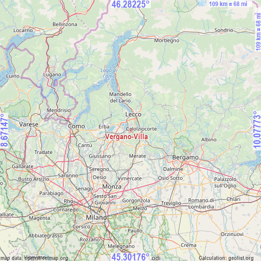
Vergano-Villa GPS coordinates[2]
45° 47' 38.976" North, 9° 22' 28.56" East
| Map corner | latitude | longitude |
|---|---|---|
| Upper-left | 46.28225°, | 8.67147° |
| Center: | 45.79416°, | 9.3746° |
| Lower-right: | 45.30176°, | 10.07773° |
| Map W x H: | 109×109 km | = 67.7×67.7mi |
| max Lat: | 47.04031° ⇑14.4% North |
| Vergano-Villa: | 45.79416° |
| min Lat: | ⇓85.6% South 35.50142° |
| min Long | Vergano-Villa | max Long |
| 6.69888° | 9.3746° | 18.48682° |
| W 25%⇐ | ⇒75% E |
Elevation
Elevation of Vergano-Villa is 526 m = 1726 ft, and this is 219.3 m = 719 ft above average elevation for this country.
| Max E: |
2085 m = 6841 ft | 20% |
| Vergano-Villa | 526 m 1726 ft | |
| Avg. | 306.7 m = 1006 ft | |
Min E: |
-4 m = -13 ft | 80% |
See also: Italy elevation on elevation.city.
Geographical zone
Vergano-Villa is located in North temperate zone (between Tropic of Cancer and the Arctic Circle). Distance of this North polar circle is 2309.3 km =1434.9 mi to North.| Distance of | km | miles | from Vergano-Villa |
|---|---|---|---|
| North Pole | 4915.2 | 3054.2 | to North |
| Arctic Circle | 2309.3 | 1434.9 | to North |
| Tropic Cancer | 2485.9 | 1544.7 | to South |
| Equator | 5091.8 | 3163.9 | to South |


Nearby cities:
15 places around Vergano-Villa: (largest is in red/bold)
• Annone di Brianza
3.5 km =2.2 mi,  284°
284°
• Castello di Brianza
4.5 km =2.8 mi,  210°
210°
• Civate
4.5 km =2.8 mi,  326°
326°
• Colle Brianza
3.6 km =2.2 mi,  192°
192°
• Dolzago
4.1 km =2.5 mi,  222°
222°
• Ello
1.2 km =0.7 mi, 217°
• Galbiate
2.5 km =1.6 mi,  7°
7°
• Garlate
2.8 km =1.7 mi,  44°
44°
• Nava
3.7 km =2.3 mi, 194°
• Oggiono
2.1 km =1.3 mi,  261°
261°
• Olginate
3.4 km =2.1 mi,  95°
95°
• Pescate
4.6 km =2.9 mi,  18°
18°
• Sala al Barro
3.1 km =1.9 mi,  341°
341°
• Valgreghentino
3.4 km =2.1 mi,  118°
118°
• Vercurago
4.1 km =2.5 mi,  65°
65°
Sources, notices
• [Note1] Compared only with cities in Italy existing in our database
• [Src1] Map data: © OpenStreetMap contributors (CC-BY-SA)
• [Src2] Other city data from geonames.org with taken over terms of usage.
• [Src3] Geographical zone / Annual Mean Temperature by Robert A. Rohde @ Wikipedia
