Novellara geodata
Novellara (Emilia-Romagna) is a seat of a third-order administrative division; located in Italy in Europe/Rome (GMT+2) time zone. With population of 10,393 people, there are 909 cities with bigger population in this country. Compared to other cities in Italy, 57% of cities are located further ↓South; 60.7% of cities are located further →East and 86.1% of cities have higher elevation than Novellara. Note1
Administrative division(s):
- Level 1: Emilia-Romagna
- Level 2: Provincia di Reggio Emilia
- Level 3: Novellara


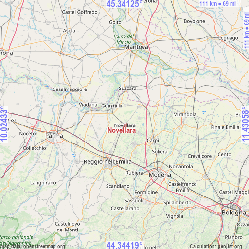
Novellara GPS coordinates[2]
44° 50' 41.568" North, 10° 43' 38.82" East
| Map corner | latitude | longitude |
|---|---|---|
| Upper-left | 45.34125°, | 10.02433° |
| Center: | 44.84488°, | 10.72745° |
| Lower-right: | 44.34419°, | 11.43058° |
| Map W x H: | 110.9×110.9 km | = 68.9×68.9mi |
| max Lat: | 47.04031° ⇑43% North |
| Novellara: | 44.84488° |
| min Lat: | ⇓57% South 35.50142° |
| min Long | Novellara | max Long |
| 6.69888° | 10.72745° | 18.48682° |
| W 39.3%⇐ | ⇒60.7% E |
Elevation
Elevation of Novellara is 28 m = 92 ft, and this is 278.7 m = 914 ft below average elevation for this country.
| Max E: |
2085 m = 6841 ft | 86.1% |
| Avg. | 306.7 m = 1006 ft | |
| Novellara | 28 m = 92 ft | |
Min E: |
-4 m = -13 ft | 13.9% |
See also: Italy elevation on elevation.city.
Geographical zone
Novellara is located in North temperate zone (between Tropic of Cancer and the Arctic Circle). Distance of this Northern Tropic circle is 2380.4 km =1479.1 mi to South.| Distance of | km | miles | from Novellara |
|---|---|---|---|
| North Pole | 5020.8 | 3119.8 | to North |
| Arctic Circle | 2414.9 | 1500.5 | to North |
| Tropic Cancer | 2380.4 | 1479.1 | to South |
| Equator | 4986.3 | 3098.3 | to South |


Nearby cities:
15 places around Novellara: (largest is in red/bold)
• Bagnolo in Piano
9.9 km =6.2 mi,  205°
205°
• Brugneto
9 km =5.6 mi,  17°
17°
• Cadelbosco di Sotto
10 km =6.2 mi,  241°
241°
• Campagnola Emilia
3 km =1.9 mi,  101°
101°
• Canolo
5.7 km =3.5 mi,  162°
162°
• Correggio
9.7 km =6 mi,  152°
152°
• Fabbrico
7.1 km =4.4 mi,  64°
64°
• Fosdondo
7.9 km =4.9 mi,  175°
175°
• Gualtieri
9.7 km =6 mi,  306°
306°
• Guastalla
9.1 km =5.7 mi,  325°
325°
• Mandrio
8.5 km =5.3 mi,  132°
132°
• Migliarina
9.4 km =5.8 mi,  114°
114°
• Rio Saliceto
7.1 km =4.4 mi,  121°
121°
• Santa Vittoria
7.5 km =4.7 mi,  278°
278°
• Villarotta
9 km =5.6 mi,  8°
8°
Sources, notices
• [Note1] Compared only with cities in Italy existing in our database
• [Src1] Map data: © OpenStreetMap contributors (CC-BY-SA)
• [Src2] Other city data from geonames.org with taken over terms of usage.
• [Src3] Geographical zone / Annual Mean Temperature by Robert A. Rohde @ Wikipedia
