Fabbrico geodata
Fabbrico (Emilia-Romagna) is a seat of a third-order administrative division; located in Italy in Europe/Rome (GMT+2) time zone. With population of 6,149 people, there are 1602 cities with bigger population in this country. Compared to other cities in Italy, 57.5% of cities are located further ↓South; 59.6% of cities are located further →East and 86.7% of cities have higher elevation than Fabbrico. Note1
Administrative division(s):
- Level 1: Emilia-Romagna
- Level 2: Provincia di Reggio Emilia
- Level 3: Fabbrico


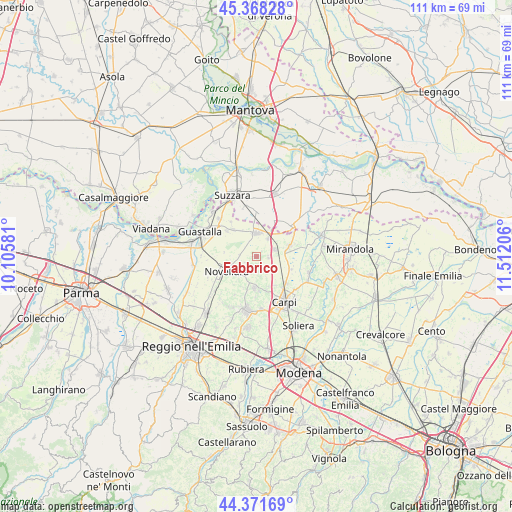
Fabbrico GPS coordinates[2]
44° 52' 19.704" North, 10° 48' 32.148" East
| Map corner | latitude | longitude |
|---|---|---|
| Upper-left | 45.36828°, | 10.10581° |
| Center: | 44.87214°, | 10.80893° |
| Lower-right: | 44.37169°, | 11.51206° |
| Map W x H: | 110.8×110.8 km | = 68.8×68.8mi |
| max Lat: | 47.04031° ⇑42.5% North |
| Fabbrico: | 44.87214° |
| min Lat: | ⇓57.5% South 35.50142° |
| min Long | Fabbrico | max Long |
| 6.69888° | 10.80893° | 18.48682° |
| W 40.4%⇐ | ⇒59.6% E |
Elevation
Elevation of Fabbrico is 26 m = 85 ft, and this is 280.7 m = 921 ft below average elevation for this country.
| Max E: |
2085 m = 6841 ft | 86.7% |
| Avg. | 306.7 m = 1006 ft | |
| Fabbrico | 26 m = 85 ft | |
Min E: |
-4 m = -13 ft | 13.3% |
See also: Italy elevation on elevation.city.
Geographical zone
Fabbrico is located in North temperate zone (between Tropic of Cancer and the Arctic Circle). Distance of this Northern Tropic circle is 2383.4 km =1481 mi to South.| Distance of | km | miles | from Fabbrico |
|---|---|---|---|
| North Pole | 5017.7 | 3117.9 | to North |
| Arctic Circle | 2411.9 | 1498.7 | to North |
| Tropic Cancer | 2383.4 | 1481 | to South |
| Equator | 4989.3 | 3100.2 | to South |


Nearby cities:
15 places around Fabbrico: (largest is in red/bold)
• Bondeno
8.1 km =5 mi,  29°
29°
• Brugneto
6.6 km =4.1 mi,  326°
326°
• Budrione
7.4 km =4.6 mi,  147°
147°
• Campagnola Emilia
5 km =3.1 mi,  223°
223°
• Canolo
9.7 km =6 mi,  209°
209°
• Fossoli
8.5 km =5.3 mi,  131°
131°
• Gonzaga
8.9 km =5.5 mi,  5°
5°
• Mandrio
8.8 km =5.5 mi,  181°
181°
• Migliarina
7.2 km =4.5 mi,  162°
162°
• Novellara
7.1 km =4.4 mi,  244°
244°
• Novi di Modena
7.5 km =4.7 mi,  74°
74°
• Reggiolo
5.1 km =3.2 mi,  1°
1°
• Rio Saliceto
6.8 km =4.2 mi, 183°
• Rolo
4.2 km =2.6 mi, 70°
• Villarotta
7.8 km =4.8 mi,  318°
318°
Sources, notices
• [Note1] Compared only with cities in Italy existing in our database
• [Src1] Map data: © OpenStreetMap contributors (CC-BY-SA)
• [Src2] Other city data from geonames.org with taken over terms of usage.
• [Src3] Geographical zone / Annual Mean Temperature by Robert A. Rohde @ Wikipedia
