Cori geodata
Cori (Latium) is a seat of a third-order administrative division; located in Italy in Europe/Rome (GMT+2) time zone. With population of 6,376 people, there are 1536 cities with bigger population in this country. Compared to other cities in Italy, 73.5% of cities are located further ↑North; 67.3% of cities are located further ←West and 56.4% of cities have lower elevation than Cori. Note1


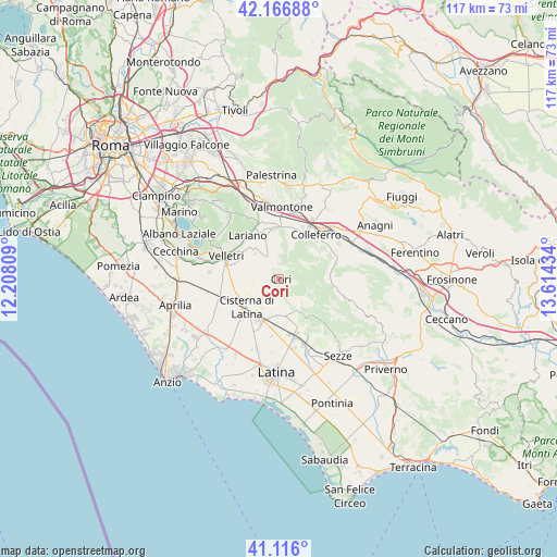
Cori GPS coordinates[2]
41° 38' 36.888" North, 12° 54' 40.356" East
| Map corner | latitude | longitude |
|---|---|---|
| Upper-left | 42.16688°, | 12.20809° |
| Center: | 41.64358°, | 12.91121° |
| Lower-right: | 41.116°, | 13.61434° |
| Map W x H: | 116.8×116.8 km | = 72.6×72.6mi |
| max Lat: | 47.04031° ⇑73.5% North |
| Cori: | 41.64358° |
| min Lat: | ⇓26.5% South 35.50142° |
| min Long | Cori | max Long |
| 6.69888° | 12.91121° | 18.48682° |
| W 67.3%⇐ | ⇒32.7% E |
Elevation
Elevation of Cori is 274 m = 899 ft, and this is 32.7 m = 107 ft below average elevation for this country.
| Max E: |
2085 m = 6841 ft | 43.6% |
| Avg. | 306.7 m = 1006 ft | |
| Cori | 274 m = 899 ft | |
Min E: |
-4 m = -13 ft | 56.4% |
See also: Italy elevation on elevation.city.
Geographical zone
Cori is located in North temperate zone (between Tropic of Cancer and the Arctic Circle). Distance of this Northern Tropic circle is 2024.4 km =1257.9 mi to South.| Distance of | km | miles | from Cori |
|---|---|---|---|
| North Pole | 5376.7 | 3340.9 | to North |
| Arctic Circle | 2770.8 | 1721.7 | to North |
| Tropic Cancer | 2024.4 | 1257.9 | to South |
| Equator | 4630.3 | 2877.1 | to South |


Nearby cities:
15 places around Cori: (largest is in red/bold)
• Artena
10.9 km =6.8 mi,  358°
358°
• Borgo Carso
12.3 km =7.6 mi,  188°
188°
• Carrara-Pontenuovo
12 km =7.5 mi,  162°
162°
• Cisterna di Latina
9.1 km =5.7 mi,  229°
229°
• Colleferro
12.1 km =7.5 mi,  39°
39°
• Colubro
10.8 km =6.7 mi,  340°
340°
• Giulianello
5.4 km =3.4 mi,  330°
330°
• Lariano
10.8 km =6.7 mi,  320°
320°
• Montelanico
10.8 km =6.7 mi,  85°
85°
• Norma
8.1 km =5 mi,  142°
142°
• Rocca Massima
4 km =2.5 mi,  11°
11°
• Segni
10.3 km =6.4 mi,  60°
60°
• Sermoneta
12.1 km =7.5 mi,  149°
149°
• Velletri
12.1 km =7.5 mi,  292°
292°
• Via Latina Iv Km
11 km =6.8 mi,  22°
22°
Sources, notices
• [Note1] Compared only with cities in Italy existing in our database
• [Src1] Map data: © OpenStreetMap contributors (CC-BY-SA)
• [Src2] Other city data from geonames.org with taken over terms of usage.
• [Src3] Geographical zone / Annual Mean Temperature by Robert A. Rohde @ Wikipedia
