Noceto geodata
Noceto (Emilia-Romagna) is a seat of a third-order administrative division; located in Italy in Europe/Rome (GMT+2) time zone. With population of 8,076 people, there are 1200 cities with bigger population in this country. Compared to other cities in Italy, 56.4% of cities are located further ↓South; 66.2% of cities are located further →East and 74.3% of cities have higher elevation than Noceto. Note1


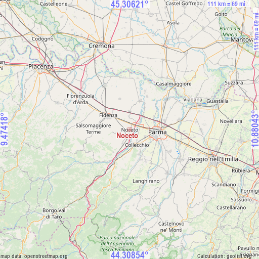
Noceto GPS coordinates[2]
44° 48' 34.308" North, 10° 10' 38.28" East
| Map corner | latitude | longitude |
|---|---|---|
| Upper-left | 45.30621°, | 9.47418° |
| Center: | 44.80953°, | 10.1773° |
| Lower-right: | 44.30854°, | 10.88043° |
| Map W x H: | 110.9×110.9 km | = 68.9×68.9mi |
| max Lat: | 47.04031° ⇑43.6% North |
| Noceto: | 44.80953° |
| min Lat: | ⇓56.4% South 35.50142° |
| min Long | Noceto | max Long |
| 6.69888° | 10.1773° | 18.48682° |
| W 33.8%⇐ | ⇒66.2% E |
Elevation
Elevation of Noceto is 77 m = 253 ft, and this is 229.7 m = 754 ft below average elevation for this country.
| Max E: |
2085 m = 6841 ft | 74.3% |
| Avg. | 306.7 m = 1006 ft | |
| Noceto | 77 m = 253 ft | |
Min E: |
-4 m = -13 ft | 25.7% |
See also: Italy elevation on elevation.city.
Geographical zone
Noceto is located in North temperate zone (between Tropic of Cancer and the Arctic Circle). Distance of this Northern Tropic circle is 2376.4 km =1476.6 mi to South.| Distance of | km | miles | from Noceto |
|---|---|---|---|
| North Pole | 5024.7 | 3122.2 | to North |
| Arctic Circle | 2418.8 | 1503 | to North |
| Tropic Cancer | 2376.4 | 1476.6 | to South |
| Equator | 4982.4 | 3095.9 | to South |


Nearby cities:
15 places around Noceto: (largest is in red/bold)
• Baganzola
11.4 km =7.1 mi,  63°
63°
• Collecchio
7.1 km =4.4 mi,  154°
154°
• Eia
7.5 km =4.7 mi,  68°
68°
• Felegara
11 km =6.8 mi,  207°
207°
• Fidenza
11.2 km =7 mi,  304°
304°
• Fontanellato
8 km =5 mi,  359°
359°
• Fontevivo
5.6 km =3.5 mi, 356°
• Gaiano
9.5 km =5.9 mi,  182°
182°
• Gaione
10.6 km =6.6 mi,  122°
122°
• Madregolo
3.9 km =2.4 mi, 119°
• Medesano
6.5 km =4 mi, 208°
• Ozzano Taro
11.5 km =7.1 mi,  194°
194°
• Ponte Taro
3.4 km =2.1 mi,  50°
50°
• Sala Baganza
11.1 km =6.9 mi,  159°
159°
• Vicofertile
7.2 km =4.5 mi,  111°
111°
Sources, notices
• [Note1] Compared only with cities in Italy existing in our database
• [Src1] Map data: © OpenStreetMap contributors (CC-BY-SA)
• [Src2] Other city data from geonames.org with taken over terms of usage.
• [Src3] Geographical zone / Annual Mean Temperature by Robert A. Rohde @ Wikipedia
