Fidenza geodata
Fidenza (Emilia-Romagna) is a seat of a third-order administrative division; located in Italy in Europe/Rome (GMT+2) time zone. With population of 21,952 people, there are 403 cities with bigger population in this country. Compared to other cities in Italy, 57.4% of cities are located further ↓South; 67.2% of cities are located further →East and 73.4% of cities have higher elevation than Fidenza. Note1


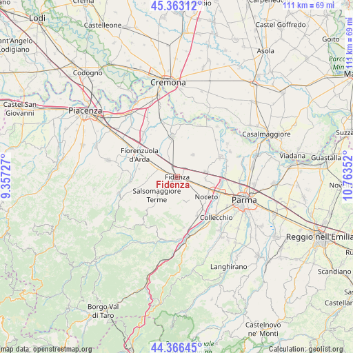
Fidenza GPS coordinates[2]
44° 52' 0.984" North, 10° 3' 37.404" East
| Map corner | latitude | longitude |
|---|---|---|
| Upper-left | 45.36312°, | 9.35727° |
| Center: | 44.86694°, | 10.06039° |
| Lower-right: | 44.36645°, | 10.76352° |
| Map W x H: | 110.8×110.8 km | = 68.8×68.8mi |
| max Lat: | 47.04031° ⇑42.6% North |
| Fidenza: | 44.86694° |
| min Lat: | ⇓57.4% South 35.50142° |
| min Long | Fidenza | max Long |
| 6.69888° | 10.06039° | 18.48682° |
| W 32.8%⇐ | ⇒67.2% E |
Elevation
Elevation of Fidenza is 81 m = 266 ft, and this is 225.7 m = 740 ft below average elevation for this country.
| Max E: |
2085 m = 6841 ft | 73.4% |
| Avg. | 306.7 m = 1006 ft | |
| Fidenza | 81 m = 266 ft | |
Min E: |
-4 m = -13 ft | 26.6% |
See also: Italy elevation on elevation.city.
Geographical zone
Fidenza is located in North temperate zone (between Tropic of Cancer and the Arctic Circle). Distance of this Northern Tropic circle is 2382.8 km =1480.6 mi to South.| Distance of | km | miles | from Fidenza |
|---|---|---|---|
| North Pole | 5018.3 | 3118.2 | to North |
| Arctic Circle | 2412.4 | 1499 | to North |
| Tropic Cancer | 2382.8 | 1480.6 | to South |
| Equator | 4988.7 | 3099.8 | to South |


Nearby cities:
15 places around Fidenza: (largest is in red/bold)
• Alseno
8.3 km =5.2 mi,  294°
294°
• Bagni di Tabiano
7.3 km =4.5 mi,  205°
205°
• Busseto
12.6 km =7.8 mi,  353°
353°
• Castell'Arquato
14.8 km =9.2 mi,  264°
264°
• Castelnuovo Fogliani
7 km =4.3 mi,  278°
278°
• Fiorenzuola d'Arda
13.2 km =8.2 mi,  298°
298°
• Fontanellato
9.3 km =5.8 mi,  79°
79°
• Fontevivo
8.9 km =5.5 mi,  95°
95°
• Lusurasco
12.1 km =7.5 mi, 281°
• Medesano
13.5 km =8.4 mi,  153°
153°
• Noceto
11.2 km =7 mi,  124°
124°
• Ponte Taro
12.6 km =7.8 mi,  109°
109°
• Salsomaggiore Terme
8.1 km =5 mi,  225°
225°
• San Secondo Parmense
14.7 km =9.1 mi,  65°
65°
• Soragna
8.2 km =5.1 mi,  35°
35°
Sources, notices
• [Note1] Compared only with cities in Italy existing in our database
• [Src1] Map data: © OpenStreetMap contributors (CC-BY-SA)
• [Src2] Other city data from geonames.org with taken over terms of usage.
• [Src3] Geographical zone / Annual Mean Temperature by Robert A. Rohde @ Wikipedia
