Medesano geodata
Medesano (Emilia-Romagna) is a seat of a third-order administrative division; located in Italy in Europe/Rome (GMT+2) time zone. With population of 3,456 people, there are 2713 cities with bigger population in this country. Compared to other cities in Italy, 55.4% of cities are located further ↓South; 66.5% of cities are located further →East and 63.9% of cities have higher elevation than Medesano. Note1


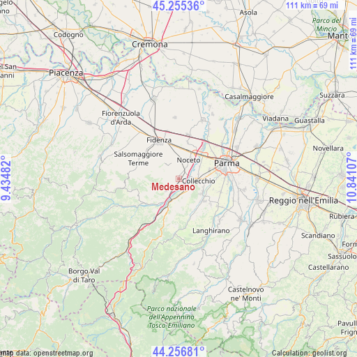
Medesano GPS coordinates[2]
44° 45' 29.664" North, 10° 8' 16.584" East
| Map corner | latitude | longitude |
|---|---|---|
| Upper-left | 45.25536°, | 9.43482° |
| Center: | 44.75824°, | 10.13794° |
| Lower-right: | 44.25681°, | 10.84107° |
| Map W x H: | 111×111 km | = 69×69mi |
| max Lat: | 47.04031° ⇑44.6% North |
| Medesano: | 44.75824° |
| min Lat: | ⇓55.4% South 35.50142° |
| min Long | Medesano | max Long |
| 6.69888° | 10.13794° | 18.48682° |
| W 33.5%⇐ | ⇒66.5% E |
Elevation
Elevation of Medesano is 135 m = 443 ft, and this is 171.7 m = 563 ft below average elevation for this country.
| Max E: |
2085 m = 6841 ft | 63.9% |
| Avg. | 306.7 m = 1006 ft | |
| Medesano | 135 m = 443 ft | |
Min E: |
-4 m = -13 ft | 36.1% |
See also: Italy elevation on elevation.city.
Geographical zone
Medesano is located in North temperate zone (between Tropic of Cancer and the Arctic Circle). Distance of this Northern Tropic circle is 2370.7 km =1473.1 mi to South.| Distance of | km | miles | from Medesano |
|---|---|---|---|
| North Pole | 5030.4 | 3125.7 | to North |
| Arctic Circle | 2424.5 | 1506.5 | to North |
| Tropic Cancer | 2370.7 | 1473.1 | to South |
| Equator | 4976.6 | 3092.3 | to South |


Nearby cities:
15 places around Medesano: (largest is in red/bold)
• Collecchio
6.2 km =3.9 mi,  96°
96°
• Felegara
4.5 km =2.8 mi,  206°
206°
• Felino
10.3 km =6.4 mi,  129°
129°
• Fornovo di Taro
7.6 km =4.7 mi,  201°
201°
• Gaiano
4.7 km =2.9 mi,  144°
144°
• Madregolo
7.6 km =4.7 mi,  60°
60°
• Noceto
6.5 km =4 mi,  28°
28°
• Ozzano Taro
5.4 km =3.4 mi,  177°
177°
• Ponte Taro
9.7 km =6 mi,  36°
36°
• Ramiola
7.4 km =4.6 mi, 209°
• Riccò
6.6 km =4.1 mi,  191°
191°
• Sala Baganza
8.4 km =5.2 mi,  124°
124°
• Salita-Riola
9.8 km =6.1 mi, 199°
• Sant'Andrea Bagni
5.5 km =3.4 mi,  224°
224°
• Vicofertile
10.3 km =6.4 mi,  72°
72°
Sources, notices
• [Note1] Compared only with cities in Italy existing in our database
• [Src1] Map data: © OpenStreetMap contributors (CC-BY-SA)
• [Src2] Other city data from geonames.org with taken over terms of usage.
• [Src3] Geographical zone / Annual Mean Temperature by Robert A. Rohde @ Wikipedia
