Fontanellato geodata
Fontanellato (Emilia-Romagna) is a seat of a third-order administrative division; located in Italy in Europe/Rome (GMT+2) time zone. With population of 3,897 people, there are 2456 cities with bigger population in this country. Compared to other cities in Italy, 57.6% of cities are located further ↓South; 66.2% of cities are located further →East and 81.5% of cities have higher elevation than Fontanellato. Note1
Administrative division(s):
- Level 1: Emilia-Romagna
- Level 2: Provincia di Parma
- Level 3: Fontanellato


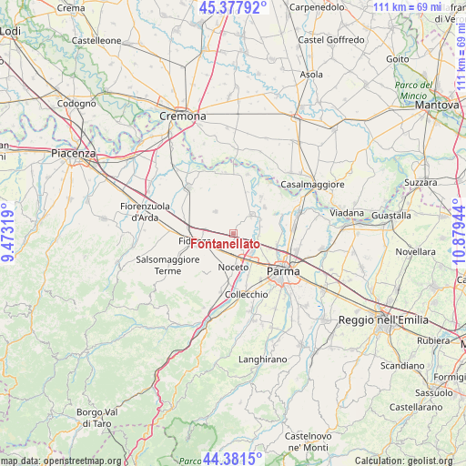
Fontanellato GPS coordinates[2]
44° 52' 54.732" North, 10° 10' 34.716" East
| Map corner | latitude | longitude |
|---|---|---|
| Upper-left | 45.37792°, | 9.47319° |
| Center: | 44.88187°, | 10.17631° |
| Lower-right: | 44.3815°, | 10.87944° |
| Map W x H: | 110.8×110.8 km | = 68.8×68.8mi |
| max Lat: | 47.04031° ⇑42.4% North |
| Fontanellato: | 44.88187° |
| min Lat: | ⇓57.6% South 35.50142° |
| min Long | Fontanellato | max Long |
| 6.69888° | 10.17631° | 18.48682° |
| W 33.8%⇐ | ⇒66.2% E |
Elevation
Elevation of Fontanellato is 44 m = 144 ft, and this is 262.7 m = 862 ft below average elevation for this country.
| Max E: |
2085 m = 6841 ft | 81.5% |
| Avg. | 306.7 m = 1006 ft | |
| Fontanellato | 44 m = 144 ft | |
Min E: |
-4 m = -13 ft | 18.5% |
See also: Italy elevation on elevation.city.
Geographical zone
Fontanellato is located in North temperate zone (between Tropic of Cancer and the Arctic Circle). Distance of this Northern Tropic circle is 2384.5 km =1481.7 mi to South.| Distance of | km | miles | from Fontanellato |
|---|---|---|---|
| North Pole | 5016.7 | 3117.2 | to North |
| Arctic Circle | 2410.8 | 1498 | to North |
| Tropic Cancer | 2384.5 | 1481.7 | to South |
| Equator | 4990.4 | 3100.9 | to South |


Nearby cities:
15 places around Fontanellato: (largest is in red/bold)
• Baganzola
10.7 km =6.6 mi,  106°
106°
• Cervara
10.4 km =6.5 mi,  100°
100°
• Eia
8.8 km =5.5 mi,  126°
126°
• Fidenza
9.3 km =5.8 mi,  259°
259°
• Fontanelle
10.2 km =6.3 mi,  17°
17°
• Fontevivo
2.5 km =1.6 mi,  186°
186°
• Madregolo
10.6 km =6.6 mi,  160°
160°
• Noceto
8 km =5 mi,  179°
179°
• Ponte Taro
6.5 km =4 mi, 155°
• Rivarolo
11.3 km =7 mi,  77°
77°
• Ronco Campo Canneto
7.1 km =4.4 mi,  68°
68°
• San Secondo Parmense
6.2 km =3.9 mi,  43°
43°
• Sissa
10.9 km =6.8 mi, 37°
• Soragna
6.7 km =4.2 mi,  318°
318°
• Trecasali
9.8 km =6.1 mi,  50°
50°
Sources, notices
• [Note1] Compared only with cities in Italy existing in our database
• [Src1] Map data: © OpenStreetMap contributors (CC-BY-SA)
• [Src2] Other city data from geonames.org with taken over terms of usage.
• [Src3] Geographical zone / Annual Mean Temperature by Robert A. Rohde @ Wikipedia
