Ranica geodata
Ranica (Lombardy) is a seat of a third-order administrative division; located in Italy in Europe/Rome (GMT+2) time zone. With population of 5,920 people, there are 1654 cities with bigger population in this country. Compared to other cities in Italy, 82.4% of cities are located further ↓South; 70.6% of cities are located further →East and 58.2% of cities have lower elevation than Ranica. Note1


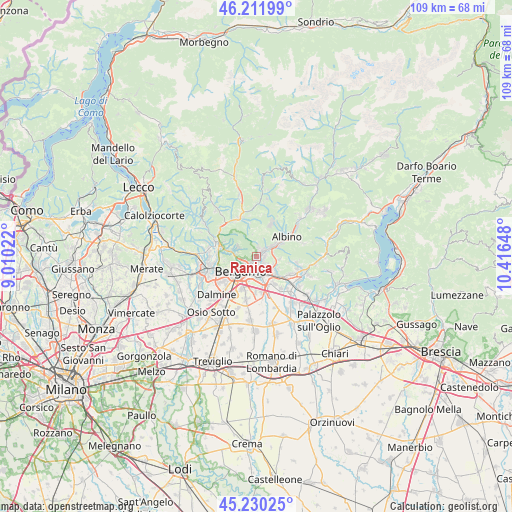
Ranica GPS coordinates[2]
45° 43' 23.808" North, 9° 42' 48.06" East
| Map corner | latitude | longitude |
|---|---|---|
| Upper-left | 46.21199°, | 9.01022° |
| Center: | 45.72328°, | 9.71335° |
| Lower-right: | 45.23025°, | 10.41648° |
| Map W x H: | 109.2×109.2 km | = 67.9×67.9mi |
| max Lat: | 47.04031° ⇑17.6% North |
| Ranica: | 45.72328° |
| min Lat: | ⇓82.4% South 35.50142° |
| min Long | Ranica | max Long |
| 6.69888° | 9.71335° | 18.48682° |
| W 29.4%⇐ | ⇒70.6% E |
Elevation
Elevation of Ranica is 287 m = 942 ft, and this is 19.7 m = 65 ft below average elevation for this country.
| Max E: |
2085 m = 6841 ft | 41.8% |
| Avg. | 306.7 m = 1006 ft | |
| Ranica | 287 m = 942 ft | |
Min E: |
-4 m = -13 ft | 58.2% |
See also: Italy elevation on elevation.city.
Geographical zone
Ranica is located in North temperate zone (between Tropic of Cancer and the Arctic Circle). Distance of this North polar circle is 2317.2 km =1439.8 mi to North.| Distance of | km | miles | from Ranica |
|---|---|---|---|
| North Pole | 4923.1 | 3059.1 | to North |
| Arctic Circle | 2317.2 | 1439.8 | to North |
| Tropic Cancer | 2478 | 1539.8 | to South |
| Equator | 5084 | 3159.1 | to South |


Nearby cities:
15 places around Ranica: (largest is in red/bold)
• Albano Sant'Alessandro
5.7 km =3.5 mi,  133°
133°
• Alzano Lombardo
1.8 km =1.1 mi,  33°
33°
• Bergamo
4.7 km =2.9 mi,  229°
229°
• Gavarno Rinnovata
3.9 km =2.4 mi,  87°
87°
• Gavarno-Tribulina
4.8 km =3 mi,  97°
97°
• Gorle
2.4 km =1.5 mi,  179°
179°
• Negrone
3.8 km =2.4 mi,  112°
112°
• Nembro
4.4 km =2.7 mi,  58°
58°
• Pedrengo
3.5 km =2.2 mi,  151°
151°
• Ponteranica
4.9 km =3 mi,  282°
282°
• Scanzo-Rosciate
2.2 km =1.4 mi, 129°
• Seriate
4.3 km =2.7 mi,  168°
168°
• Torre Boldone
0.8 km =0.5 mi,  212°
212°
• Torre de' Roveri
4.8 km =3 mi, 126°
• Villa di Serio
1.7 km =1.1 mi, 92°
Sources, notices
• [Note1] Compared only with cities in Italy existing in our database
• [Src1] Map data: © OpenStreetMap contributors (CC-BY-SA)
• [Src2] Other city data from geonames.org with taken over terms of usage.
• [Src3] Geographical zone / Annual Mean Temperature by Robert A. Rohde @ Wikipedia
