Gorga geodata
Gorga (Latium) is a seat of a third-order administrative division; located in Italy in Europe/Rome (GMT+2) time zone. With population of 472 people, there are 10014 cities with bigger population in this country. Compared to other cities in Italy, 73.4% of cities are located further ↑North; 69.5% of cities are located further ←West and 91.7% of cities have lower elevation than Gorga. Note1
Administrative division(s):
- Level 1: Latium
- Level 2: Città metropolitana di Roma Capitale
- Level 3: Gorga


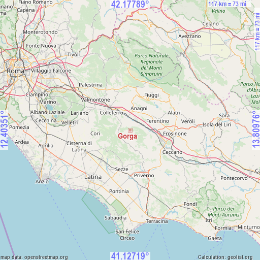
Gorga GPS coordinates[2]
41° 39' 16.848" North, 13° 6' 23.868" East
| Map corner | latitude | longitude |
|---|---|---|
| Upper-left | 42.17789°, | 12.40351° |
| Center: | 41.65468°, | 13.10663° |
| Lower-right: | 41.12719°, | 13.80976° |
| Map W x H: | 116.8×116.8 km | = 72.6×72.6mi |
| max Lat: | 47.04031° ⇑73.4% North |
| Gorga: | 41.65468° |
| min Lat: | ⇓26.6% South 35.50142° |
| min Long | Gorga | max Long |
| 6.69888° | 13.10663° | 18.48682° |
| W 69.5%⇐ | ⇒30.5% E |
Elevation
Elevation of Gorga is 760 m = 2493 ft, and this is 453.3 m = 1487 ft above average elevation for this country.
| Max E: |
2085 m = 6841 ft | 8.3% |
| Gorga | 760 m 2493 ft | |
| Avg. | 306.7 m = 1006 ft | |
Min E: |
-4 m = -13 ft | 91.7% |
See also: Italy elevation on elevation.city.
Geographical zone
Gorga is located in North temperate zone (between Tropic of Cancer and the Arctic Circle). Distance of this Northern Tropic circle is 2025.6 km =1258.6 mi to South.| Distance of | km | miles | from Gorga |
|---|---|---|---|
| North Pole | 5375.5 | 3340.2 | to North |
| Arctic Circle | 2769.6 | 1720.9 | to North |
| Tropic Cancer | 2025.6 | 1258.6 | to South |
| Equator | 4631.6 | 2877.9 | to South |


Nearby cities:
15 places around Gorga: (largest is in red/bold)
• Anagni
10.7 km =6.6 mi,  22°
22°
• Carpineto Romano
5.9 km =3.7 mi,  198°
198°
• Cartiera-Stazione
11.2 km =7 mi,  89°
89°
• Cerquotti-Madonna del Piano
9 km =5.6 mi,  99°
99°
• Colleferro
11.7 km =7.3 mi,  313°
313°
• Gavignano
6.8 km =4.2 mi,  316°
316°
• Madonna delle Grazie Iacp
9.5 km =5.9 mi, 23°
• Montelanico
5.5 km =3.4 mi,  265°
265°
• Morolo
7.8 km =4.8 mi, 103°
• Osteria della Fontana
8.8 km =5.5 mi, 20°
• Segni
8.2 km =5.1 mi,  297°
297°
• Sgurgola
3.9 km =2.4 mi,  66°
66°
• Supino
11.3 km =7 mi,  109°
109°
• Tofe
10.1 km =6.3 mi, 70°
• Tufano
11.8 km =7.3 mi,  44°
44°
Sources, notices
• [Note1] Compared only with cities in Italy existing in our database
• [Src1] Map data: © OpenStreetMap contributors (CC-BY-SA)
• [Src2] Other city data from geonames.org with taken over terms of usage.
• [Src3] Geographical zone / Annual Mean Temperature by Robert A. Rohde @ Wikipedia
