Monteverde geodata
Monteverde (Campania) is a seat of a third-order administrative division; located in Italy in Europe/Rome (GMT+2) time zone. With population of 790 people, there are 7704 cities with bigger population in this country. Compared to other cities in Italy, 78.6% of cities are located further ↑North; 90.7% of cities are located further ←West and 89.7% of cities have lower elevation than Monteverde. Note1


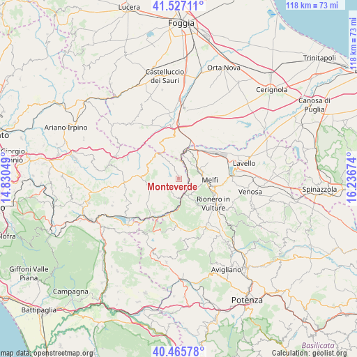
Monteverde GPS coordinates[2]
40° 59' 54.888" North, 15° 32' 0.996" East
| Map corner | latitude | longitude |
|---|---|---|
| Upper-left | 41.52711°, | 14.83049° |
| Center: | 40.99858°, | 15.53361° |
| Lower-right: | 40.46578°, | 16.23674° |
| Map W x H: | 118×118 km | = 73.3×73.3mi |
| max Lat: | 47.04031° ⇑78.6% North |
| Monteverde: | 40.99858° |
| min Lat: | ⇓21.4% South 35.50142° |
| min Long | Monteverde | max Long |
| 6.69888° | 15.53361° | 18.48682° |
| W 90.7%⇐ | ⇒9.3% E |
Elevation
Elevation of Monteverde is 712 m = 2336 ft, and this is 405.3 m = 1330 ft above average elevation for this country.
| Max E: |
2085 m = 6841 ft | 10.3% |
| Monteverde | 712 m 2336 ft | |
| Avg. | 306.7 m = 1006 ft | |
Min E: |
-4 m = -13 ft | 89.7% |
See also: Italy elevation on elevation.city.
Geographical zone
Monteverde is located in North temperate zone (between Tropic of Cancer and the Arctic Circle). Distance of this Northern Tropic circle is 1952.7 km =1213.4 mi to South.| Distance of | km | miles | from Monteverde |
|---|---|---|---|
| North Pole | 5448.4 | 3385.5 | to North |
| Arctic Circle | 2842.6 | 1766.3 | to North |
| Tropic Cancer | 1952.7 | 1213.4 | to South |
| Equator | 4558.6 | 2832.6 | to South |


Nearby cities:
15 places around Monteverde: (largest is in red/bold)
• Aquilonia
5.1 km =3.2 mi,  255°
255°
• Atella
16.7 km =10.4 mi,  143°
143°
• Barile
13.1 km =8.1 mi,  117°
117°
• Bisaccia
13.2 km =8.2 mi,  275°
275°
• Bisaccia Nuova
15 km =9.3 mi,  274°
274°
• Calitri
13.6 km =8.5 mi,  233°
233°
• Candela
15.4 km =9.6 mi,  354°
354°
• Lacedonia
11 km =6.8 mi,  301°
301°
• Melfi
10.3 km =6.4 mi,  91°
91°
• Rapolla
11.9 km =7.4 mi,  102°
102°
• Rapone
17.1 km =10.6 mi,  190°
190°
• Rionero in Vulture
14.3 km =8.9 mi,  125°
125°
• Rocchetta Sant'Antonio
13.2 km =8.2 mi,  332°
332°
• Ruvo del Monte
16.6 km =10.3 mi,  177°
177°
• Zona 179
7.2 km =4.5 mi, 85°
Sources, notices
• [Note1] Compared only with cities in Italy existing in our database
• [Src1] Map data: © OpenStreetMap contributors (CC-BY-SA)
• [Src2] Other city data from geonames.org with taken over terms of usage.
• [Src3] Geographical zone / Annual Mean Temperature by Robert A. Rohde @ Wikipedia
