Lacedonia geodata
Lacedonia (Campania) is a seat of a third-order administrative division; located in Italy in Europe/Rome (GMT+2) time zone. With population of 1,862 people, there are 4392 cities with bigger population in this country. Compared to other cities in Italy, 78% of cities are located further ↑North; 90.3% of cities are located further ←West and 90.3% of cities have lower elevation than Lacedonia. Note1


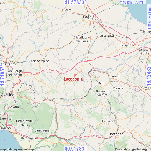
Lacedonia GPS coordinates[2]
41° 3' 0.792" North, 15° 25' 18.084" East
| Map corner | latitude | longitude |
|---|---|---|
| Upper-left | 41.57833°, | 14.71857° |
| Center: | 41.05022°, | 15.42169° |
| Lower-right: | 40.51783°, | 16.12482° |
| Map W x H: | 117.9×117.9 km | = 73.3×73.3mi |
| max Lat: | 47.04031° ⇑78% North |
| Lacedonia: | 41.05022° |
| min Lat: | ⇓22% South 35.50142° |
| min Long | Lacedonia | max Long |
| 6.69888° | 15.42169° | 18.48682° |
| W 90.3%⇐ | ⇒9.7% E |
Elevation
Elevation of Lacedonia is 728 m = 2388 ft, and this is 421.3 m = 1382 ft above average elevation for this country.
| Max E: |
2085 m = 6841 ft | 9.7% |
| Lacedonia | 728 m 2388 ft | |
| Avg. | 306.7 m = 1006 ft | |
Min E: |
-4 m = -13 ft | 90.3% |
See also: Italy elevation on elevation.city.
Geographical zone
Lacedonia is located in North temperate zone (between Tropic of Cancer and the Arctic Circle). Distance of this Northern Tropic circle is 1958.4 km =1216.9 mi to South.| Distance of | km | miles | from Lacedonia |
|---|---|---|---|
| North Pole | 5442.7 | 3381.9 | to North |
| Arctic Circle | 2836.8 | 1762.7 | to North |
| Tropic Cancer | 1958.4 | 1216.9 | to South |
| Equator | 4564.4 | 2836.2 | to South |


Nearby cities:
15 places around Lacedonia: (largest is in red/bold)
• Accadia
14.2 km =8.8 mi,  327°
327°
• Andretta-Mattinella
14.9 km =9.3 mi,  212°
212°
• Anzano di Puglia
13.8 km =8.6 mi,  305°
305°
• Aquilonia
8.3 km =5.2 mi,  147°
147°
• Bisaccia
5.9 km =3.7 mi,  219°
219°
• Bisaccia Nuova
7.2 km =4.5 mi,  230°
230°
• Calitri
13.9 km =8.6 mi,  186°
186°
• Candela
12.4 km =7.7 mi,  39°
39°
• Monteverde
11 km =6.8 mi,  121°
121°
• Rocchetta Sant'Antonio
6.7 km =4.2 mi,  28°
28°
• Sant'Agata di Puglia
11.8 km =7.3 mi,  342°
342°
• Scampitella
11.2 km =7 mi,  294°
294°
• Trevico
15.8 km =9.8 mi,  269°
269°
• Vallata
14.1 km =8.8 mi, 265°
• Vallesaccarda
14.3 km =8.9 mi,  275°
275°
Sources, notices
• [Note1] Compared only with cities in Italy existing in our database
• [Src1] Map data: © OpenStreetMap contributors (CC-BY-SA)
• [Src2] Other city data from geonames.org with taken over terms of usage.
• [Src3] Geographical zone / Annual Mean Temperature by Robert A. Rohde @ Wikipedia
