Monterado geodata
Monterado (The Marches) is a seat of a third-order administrative division; located in Italy in Europe/Rome (GMT+2) time zone. With population of 525 people, there are 9685 cities with bigger population in this country. Compared to other cities in Italy, 58.1% of cities are located further ↑North; 69.3% of cities are located further ←West and 61.5% of cities have higher elevation than Monterado. Note1


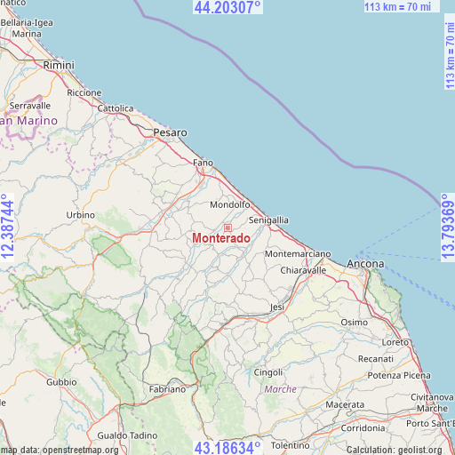
Monterado GPS coordinates[2]
43° 41' 48.696" North, 13° 5' 26.016" East
| Map corner | latitude | longitude |
|---|---|---|
| Upper-left | 44.20307°, | 12.38744° |
| Center: | 43.69686°, | 13.09056° |
| Lower-right: | 43.18634°, | 13.79369° |
| Map W x H: | 113×113 km | = 70.2×70.2mi |
| max Lat: | 47.04031° ⇑58.1% North |
| Monterado: | 43.69686° |
| min Lat: | ⇓41.9% South 35.50142° |
| min Long | Monterado | max Long |
| 6.69888° | 13.09056° | 18.48682° |
| W 69.3%⇐ | ⇒30.7% E |
Elevation
Elevation of Monterado is 152 m = 499 ft, and this is 154.7 m = 508 ft below average elevation for this country.
| Max E: |
2085 m = 6841 ft | 61.5% |
| Avg. | 306.7 m = 1006 ft | |
| Monterado | 152 m = 499 ft | |
Min E: |
-4 m = -13 ft | 38.5% |
See also: Italy elevation on elevation.city.
Geographical zone
Monterado is located in North temperate zone (between Tropic of Cancer and the Arctic Circle). Distance of this Northern Tropic circle is 2252.7 km =1399.8 mi to South.| Distance of | km | miles | from Monterado |
|---|---|---|---|
| North Pole | 5148.4 | 3199.1 | to North |
| Arctic Circle | 2542.5 | 1579.8 | to North |
| Tropic Cancer | 2252.7 | 1399.8 | to South |
| Equator | 4858.6 | 3019 | to South |


Nearby cities:
15 places around Monterado: (largest is in red/bold)
• Casine
8.4 km =5.2 mi,  149°
149°
• Castelvecchio
2.5 km =1.6 mi,  275°
275°
• Corinaldo
6.7 km =4.2 mi,  201°
201°
• Marotta
8.8 km =5.5 mi,  31°
31°
• Mondolfo
5.5 km =3.4 mi,  9°
9°
• Monte Porzio
3.6 km =2.2 mi,  259°
259°
• Orciano di Pesaro
9.6 km =6 mi,  265°
265°
• Passo Ripe
5.2 km =3.2 mi, 151°
• Pianello
8.5 km =5.3 mi,  157°
157°
• Ripe
3.3 km =2.1 mi, 158°
• San Costanzo
7.9 km =4.9 mi,  349°
349°
• San Giorgio di Pesaro
9.4 km =5.8 mi,  287°
287°
• San Michele
8.4 km =5.2 mi,  242°
242°
• Solfanuccio
7 km =4.3 mi,  338°
338°
• Vallone
8.1 km =5 mi,  103°
103°
Sources, notices
• [Note1] Compared only with cities in Italy existing in our database
• [Src1] Map data: © OpenStreetMap contributors (CC-BY-SA)
• [Src2] Other city data from geonames.org with taken over terms of usage.
• [Src3] Geographical zone / Annual Mean Temperature by Robert A. Rohde @ Wikipedia
