Castelvecchio geodata
Castelvecchio (The Marches) is a populated place; located in Italy in Europe/Rome (GMT+2) time zone. With population of 850 people, there are 7408 cities with bigger population in this country. Compared to other cities in Italy, 58.1% of cities are located further ↑North; 68.9% of cities are located further ←West and 74.9% of cities have higher elevation than Castelvecchio. Note1
Administrative division(s):
- Level 1: The Marches
- Level 2: Provincia di Pesaro e Urbino
- Level 3: Monte Porzio


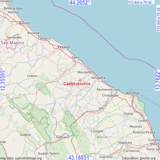
Castelvecchio GPS coordinates[2]
43° 41' 56.436" North, 13° 3' 32.652" East
| Map corner | latitude | longitude |
|---|---|---|
| Upper-left | 44.2052°, | 12.35595° |
| Center: | 43.69901°, | 13.05907° |
| Lower-right: | 43.18851°, | 13.7622° |
| Map W x H: | 113×113 km | = 70.2×70.2mi |
| max Lat: | 47.04031° ⇑58.1% North |
| Castelvecchio: | 43.69901° |
| min Lat: | ⇓41.9% South 35.50142° |
| min Long | Castelvecchio | max Long |
| 6.69888° | 13.05907° | 18.48682° |
| W 68.9%⇐ | ⇒31.1% E |
Elevation
Elevation of Castelvecchio is 74 m = 243 ft, and this is 232.7 m = 763 ft below average elevation for this country.
| Max E: |
2085 m = 6841 ft | 74.9% |
| Avg. | 306.7 m = 1006 ft | |
| Castelvecchio | 74 m = 243 ft | |
Min E: |
-4 m = -13 ft | 25.1% |
See also: Italy elevation on elevation.city.
Geographical zone
Castelvecchio is located in North temperate zone (between Tropic of Cancer and the Arctic Circle). Distance of this Northern Tropic circle is 2253 km =1399.9 mi to South.| Distance of | km | miles | from Castelvecchio |
|---|---|---|---|
| North Pole | 5148.2 | 3198.9 | to North |
| Arctic Circle | 2542.3 | 1579.7 | to North |
| Tropic Cancer | 2253 | 1399.9 | to South |
| Equator | 4858.9 | 3019.2 | to South |


Nearby cities:
15 places around Castelvecchio: (largest is in red/bold)
• Corinaldo
6.4 km =4 mi,  179°
179°
• Marotta
10.1 km =6.3 mi,  44°
44°
• Mondavio
8 km =5 mi,  250°
250°
• Mondolfo
6.2 km =3.9 mi,  34°
34°
• Monte Porzio
1.3 km =0.8 mi,  228°
228°
• Monterado
2.5 km =1.6 mi,  95°
95°
• Orciano di Pesaro
7.1 km =4.4 mi,  261°
261°
• Passo Ripe
7 km =4.3 mi,  133°
133°
• Piagge
8.2 km =5.1 mi,  297°
297°
• Pianello
9.9 km =6.2 mi,  144°
144°
• Ripe
5 km =3.1 mi, 131°
• San Costanzo
7.7 km =4.8 mi,  8°
8°
• San Giorgio di Pesaro
6.9 km =4.3 mi,  292°
292°
• San Michele
6.4 km =4 mi, 230°
• Solfanuccio
6.3 km =3.9 mi,  359°
359°
Sources, notices
• [Note1] Compared only with cities in Italy existing in our database
• [Src1] Map data: © OpenStreetMap contributors (CC-BY-SA)
• [Src2] Other city data from geonames.org with taken over terms of usage.
• [Src3] Geographical zone / Annual Mean Temperature by Robert A. Rohde @ Wikipedia
