Solfanuccio geodata
Solfanuccio (The Marches) is a populated place; located in Italy in Europe/Rome (GMT+2) time zone. With population of 506 people, there are 9871 cities with bigger population in this country. Compared to other cities in Italy, 57.5% of cities are located further ↑North; 68.9% of cities are located further ←West and 59.8% of cities have higher elevation than Solfanuccio. Note1
Administrative division(s):
- Level 1: The Marches
- Level 2: Provincia di Pesaro e Urbino
- Level 3: San Costanzo


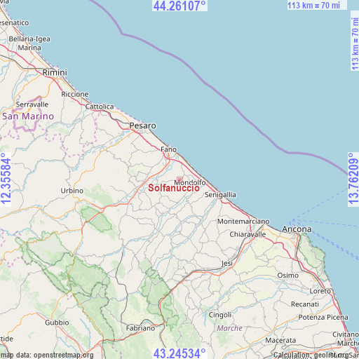
Solfanuccio GPS coordinates[2]
43° 45' 19.296" North, 13° 3' 32.256" East
| Map corner | latitude | longitude |
|---|---|---|
| Upper-left | 44.26107°, | 12.35584° |
| Center: | 43.75536°, | 13.05896° |
| Lower-right: | 43.24534°, | 13.76209° |
| Map W x H: | 112.9×112.9 km | = 70.2×70.2mi |
| max Lat: | 47.04031° ⇑57.5% North |
| Solfanuccio: | 43.75536° |
| min Lat: | ⇓42.5% South 35.50142° |
| min Long | Solfanuccio | max Long |
| 6.69888° | 13.05896° | 18.48682° |
| W 68.9%⇐ | ⇒31.1% E |
Elevation
Elevation of Solfanuccio is 165 m = 541 ft, and this is 141.7 m = 465 ft below average elevation for this country.
| Max E: |
2085 m = 6841 ft | 59.8% |
| Avg. | 306.7 m = 1006 ft | |
| Solfanuccio | 165 m = 541 ft | |
Min E: |
-4 m = -13 ft | 40.2% |
See also: Italy elevation on elevation.city.
Geographical zone
Solfanuccio is located in North temperate zone (between Tropic of Cancer and the Arctic Circle). Distance of this Northern Tropic circle is 2259.2 km =1403.8 mi to South.| Distance of | km | miles | from Solfanuccio |
|---|---|---|---|
| North Pole | 5141.9 | 3195 | to North |
| Arctic Circle | 2536 | 1575.8 | to North |
| Tropic Cancer | 2259.2 | 1403.8 | to South |
| Equator | 4865.1 | 3023 | to South |


Nearby cities:
15 places around Solfanuccio: (largest is in red/bold)
• Bellocchi
6.2 km =3.9 mi,  316°
316°
• Castelvecchio
6.3 km =3.9 mi,  179°
179°
• Cuccurano
9 km =5.6 mi,  297°
297°
• Lucrezia
9.8 km =6.1 mi,  281°
281°
• Marotta
5.6 km =3.5 mi,  30°
30°
• Marotta
7.2 km =4.5 mi,  82°
82°
• Mondolfo
3.7 km =2.3 mi,  107°
107°
• Monte Porzio
7.2 km =4.5 mi,  187°
187°
• Montemaggiore al Metauro
9.4 km =5.8 mi,  257°
257°
• Monterado
7 km =4.3 mi,  158°
158°
• Piagge
7.7 km =4.8 mi,  251°
251°
• Rosciano
8.3 km =5.2 mi, 324°
• San Costanzo
1.7 km =1.1 mi,  40°
40°
• San Giorgio di Pesaro
7.3 km =4.5 mi,  240°
240°
• Tombaccia
7.4 km =4.6 mi,  356°
356°
Sources, notices
• [Note1] Compared only with cities in Italy existing in our database
• [Src1] Map data: © OpenStreetMap contributors (CC-BY-SA)
• [Src2] Other city data from geonames.org with taken over terms of usage.
• [Src3] Geographical zone / Annual Mean Temperature by Robert A. Rohde @ Wikipedia
