Trequanda geodata
Trequanda (Tuscany) is a seat of a third-order administrative division; located in Italy in Europe/Rome (GMT+2) time zone. With population of 452 people, there are 10085 cities with bigger population in this country. Compared to other cities in Italy, 61.9% of cities are located further ↑North; 51.4% of cities are located further ←West and 73.7% of cities have lower elevation than Trequanda. Note1


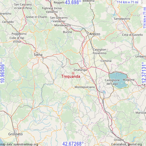
Trequanda GPS coordinates[2]
43° 11' 14.964" North, 11° 40' 5.448" East
| Map corner | latitude | longitude |
|---|---|---|
| Upper-left | 43.698°, | 10.96506° |
| Center: | 43.18749°, | 11.66818° |
| Lower-right: | 42.67268°, | 12.37131° |
| Map W x H: | 114×114 km | = 70.8×70.8mi |
| max Lat: | 47.04031° ⇑61.9% North |
| Trequanda: | 43.18749° |
| min Lat: | ⇓38.1% South 35.50142° |
| min Long | Trequanda | max Long |
| 6.69888° | 11.66818° | 18.48682° |
| W 51.4%⇐ | ⇒48.6% E |
Elevation
Elevation of Trequanda is 434 m = 1424 ft, and this is 127.3 m = 418 ft above average elevation for this country.
| Max E: |
2085 m = 6841 ft | 26.3% |
| Trequanda | 434 m 1424 ft | |
| Avg. | 306.7 m = 1006 ft | |
Min E: |
-4 m = -13 ft | 73.7% |
See also: Italy elevation on elevation.city.
Geographical zone
Trequanda is located in North temperate zone (between Tropic of Cancer and the Arctic Circle). Distance of this Northern Tropic circle is 2196.1 km =1364.6 mi to South.| Distance of | km | miles | from Trequanda |
|---|---|---|---|
| North Pole | 5205.1 | 3234.3 | to North |
| Arctic Circle | 2599.2 | 1615.1 | to North |
| Tropic Cancer | 2196.1 | 1364.6 | to South |
| Equator | 4802 | 2983.8 | to South |


Nearby cities:
15 places around Trequanda: (largest is in red/bold)
• Asciano
9.6 km =6 mi,  301°
301°
• Bettolle
11.2 km =7 mi,  78°
78°
• Foiano della Chiana
14.1 km =8.8 mi,  58°
58°
• Gracciano
14.4 km =8.9 mi,  115°
115°
• Guazzino
9.7 km =6 mi,  73°
73°
• Lucignano
11.4 km =7.1 mi,  33°
33°
• Montepulciano
13.7 km =8.5 mi,  135°
135°
• Pienza
12.1 km =7.5 mi,  176°
176°
• Rapolano Terme
13.1 km =8.1 mi,  336°
336°
• San Giovanni d'Asso
7.4 km =4.6 mi,  239°
239°
• San Quirico d'Orcia
15.3 km =9.5 mi,  199°
199°
• Serre di Rapolano
8.7 km =5.4 mi,  331°
331°
• Sinalunga
6.9 km =4.3 mi, 63°
• Torrenieri
14.9 km =9.3 mi,  220°
220°
• Torrita di Siena
9.5 km =5.9 mi,  100°
100°
Sources, notices
• [Note1] Compared only with cities in Italy existing in our database
• [Src1] Map data: © OpenStreetMap contributors (CC-BY-SA)
• [Src2] Other city data from geonames.org with taken over terms of usage.
• [Src3] Geographical zone / Annual Mean Temperature by Robert A. Rohde @ Wikipedia
