Sinalunga geodata
Sinalunga (Tuscany) is a seat of a third-order administrative division; located in Italy in Europe/Rome (GMT+2) time zone. With population of 6,567 people, there are 1491 cities with bigger population in this country. Compared to other cities in Italy, 61.7% of cities are located further ↑North; 52.4% of cities are located further ←West and 55.3% of cities have lower elevation than Sinalunga. Note1


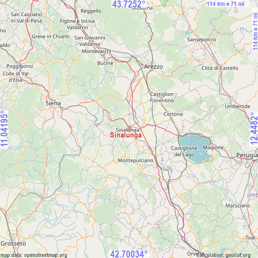
Sinalunga GPS coordinates[2]
43° 12' 53.712" North, 11° 44' 42.252" East
| Map corner | latitude | longitude |
|---|---|---|
| Upper-left | 43.7252°, | 11.04195° |
| Center: | 43.21492°, | 11.74507° |
| Lower-right: | 42.70034°, | 12.4482° |
| Map W x H: | 114×114 km | = 70.8×70.8mi |
| max Lat: | 47.04031° ⇑61.7% North |
| Sinalunga: | 43.21492° |
| min Lat: | ⇓38.3% South 35.50142° |
| min Long | Sinalunga | max Long |
| 6.69888° | 11.74507° | 18.48682° |
| W 52.4%⇐ | ⇒47.6% E |
Elevation
Elevation of Sinalunga is 267 m = 876 ft, and this is 39.7 m = 130 ft below average elevation for this country.
| Max E: |
2085 m = 6841 ft | 44.7% |
| Avg. | 306.7 m = 1006 ft | |
| Sinalunga | 267 m = 876 ft | |
Min E: |
-4 m = -13 ft | 55.3% |
See also: Italy elevation on elevation.city.
Geographical zone
Sinalunga is located in North temperate zone (between Tropic of Cancer and the Arctic Circle). Distance of this Northern Tropic circle is 2199.1 km =1366.5 mi to South.| Distance of | km | miles | from Sinalunga |
|---|---|---|---|
| North Pole | 5202 | 3232.4 | to North |
| Arctic Circle | 2596.1 | 1613.1 | to North |
| Tropic Cancer | 2199.1 | 1366.5 | to South |
| Equator | 4805 | 2985.7 | to South |


Nearby cities:
15 places around Sinalunga: (largest is in red/bold)
• Bettolle
4.8 km =3 mi,  100°
100°
• Cesa
12.5 km =7.8 mi,  25°
25°
• Foiano della Chiana
7.2 km =4.5 mi,  53°
53°
• Gracciano
11.4 km =7.1 mi,  143°
143°
• Guazzino
3 km =1.9 mi,  94°
94°
• Lucignano
6.4 km =4 mi,  0°
0°
• Marciano
10.9 km =6.8 mi,  20°
20°
• Marciano della Chiana
10.6 km =6.6 mi, 18°
• Monte San Savino
13.1 km =8.1 mi,  353°
353°
• Montepulciano
13.2 km =8.2 mi,  165°
165°
• Montepulciano Stazione
12.6 km =7.8 mi,  134°
134°
• Pozzo della Chiana
9.7 km =6 mi, 27°
• Serre di Rapolano
11.4 km =7.1 mi,  293°
293°
• Torrita di Siena
5.7 km =3.5 mi,  146°
146°
• Trequanda
6.9 km =4.3 mi,  243°
243°
Sources, notices
• [Note1] Compared only with cities in Italy existing in our database
• [Src1] Map data: © OpenStreetMap contributors (CC-BY-SA)
• [Src2] Other city data from geonames.org with taken over terms of usage.
• [Src3] Geographical zone / Annual Mean Temperature by Robert A. Rohde @ Wikipedia
