Barchi geodata
Barchi (The Marches) is a seat of a third-order administrative division; located in Italy in Europe/Rome (GMT+2) time zone. With population of 551 people, there are 9440 cities with bigger population in this country. Compared to other cities in Italy, 58.4% of cities are located further ↑North; 67.5% of cities are located further ←West and 62.5% of cities have lower elevation than Barchi. Note1
Administrative division(s):
- Level 1: The Marches
- Level 2: Provincia di Pesaro e Urbino
- Level 3: Terre Roveresche


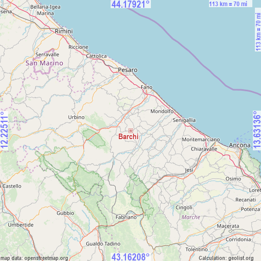
Barchi GPS coordinates[2]
43° 40' 22.08" North, 12° 55' 41.628" East
| Map corner | latitude | longitude |
|---|---|---|
| Upper-left | 44.17921°, | 12.22511° |
| Center: | 43.6728°, | 12.92823° |
| Lower-right: | 43.16208°, | 13.63136° |
| Map W x H: | 113.1×113.1 km | = 70.3×70.3mi |
| max Lat: | 47.04031° ⇑58.4% North |
| Barchi: | 43.6728° |
| min Lat: | ⇓41.6% South 35.50142° |
| min Long | Barchi | max Long |
| 6.69888° | 12.92823° | 18.48682° |
| W 67.5%⇐ | ⇒32.5% E |
Elevation
Elevation of Barchi is 319 m = 1047 ft, and this is 12.3 m = 40 ft above average elevation for this country.
| Max E: |
2085 m = 6841 ft | 37.5% |
| Barchi | 319 m 1047 ft | |
| Avg. | 306.7 m = 1006 ft | |
Min E: |
-4 m = -13 ft | 62.5% |
See also: Italy elevation on elevation.city.
Geographical zone
Barchi is located in North temperate zone (between Tropic of Cancer and the Arctic Circle). Distance of this Northern Tropic circle is 2250 km =1398.1 mi to South.| Distance of | km | miles | from Barchi |
|---|---|---|---|
| North Pole | 5151.1 | 3200.7 | to North |
| Arctic Circle | 2545.2 | 1581.5 | to North |
| Tropic Cancer | 2250 | 1398.1 | to South |
| Equator | 4856 | 3017.4 | to South |


Nearby cities:
15 places around Barchi: (largest is in red/bold)
• Borgaccio
8 km =5 mi,  348°
348°
• Calcinelli
9.1 km =5.7 mi,  355°
355°
• Castelleone di Suasa
8.2 km =5.1 mi,  150°
150°
• Fratte Rosa
4.8 km =3 mi,  205°
205°
• Mondavio
3 km =1.9 mi,  86°
86°
• Montemaggiore al Metauro
7.2 km =4.5 mi,  10°
10°
• Orciano di Pesaro
4 km =2.5 mi,  62°
62°
• Piagge
7.5 km =4.7 mi,  25°
25°
• Saltara
9.2 km =5.7 mi,  344°
344°
• San Giorgio di Pesaro
6.9 km =4.3 mi,  36°
36°
• San Lorenzo in Campo
8 km =5 mi,  170°
170°
• San Michele
5.7 km =3.5 mi,  101°
101°
• Sant'Ippolito
4.3 km =2.7 mi,  280°
280°
• Tavernelle
7.5 km =4.7 mi,  331°
331°
• Villanova
7.4 km =4.6 mi,  4°
4°
Sources, notices
• [Note1] Compared only with cities in Italy existing in our database
• [Src1] Map data: © OpenStreetMap contributors (CC-BY-SA)
• [Src2] Other city data from geonames.org with taken over terms of usage.
• [Src3] Geographical zone / Annual Mean Temperature by Robert A. Rohde @ Wikipedia
