Barzago geodata
Barzago (Lombardy) is a seat of a third-order administrative division; located in Italy in Europe/Rome (GMT+2) time zone. With population of 2,236 people, there are 3825 cities with bigger population in this country. Compared to other cities in Italy, 83.8% of cities are located further ↓South; 76.1% of cities are located further →East and 66.1% of cities have lower elevation than Barzago. Note1


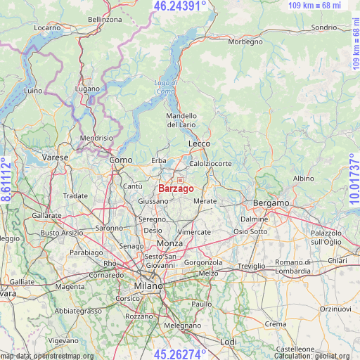
Barzago GPS coordinates[2]
45° 45' 19.728" North, 9° 18' 51.264" East
| Map corner | latitude | longitude |
|---|---|---|
| Upper-left | 46.24391°, | 8.61112° |
| Center: | 45.75548°, | 9.31424° |
| Lower-right: | 45.26274°, | 10.01737° |
| Map W x H: | 109.1×109.1 km | = 67.8×67.8mi |
| max Lat: | 47.04031° ⇑16.2% North |
| Barzago: | 45.75548° |
| min Lat: | ⇓83.8% South 35.50142° |
| min Long | Barzago | max Long |
| 6.69888° | 9.31424° | 18.48682° |
| W 23.9%⇐ | ⇒76.1% E |
Elevation
Elevation of Barzago is 354 m = 1161 ft, and this is 47.3 m = 155 ft above average elevation for this country.
| Max E: |
2085 m = 6841 ft | 33.9% |
| Barzago | 354 m 1161 ft | |
| Avg. | 306.7 m = 1006 ft | |
Min E: |
-4 m = -13 ft | 66.1% |
See also: Italy elevation on elevation.city.
Geographical zone
Barzago is located in North temperate zone (between Tropic of Cancer and the Arctic Circle). Distance of this North polar circle is 2313.6 km =1437.6 mi to North.| Distance of | km | miles | from Barzago |
|---|---|---|---|
| North Pole | 4919.5 | 3056.8 | to North |
| Arctic Circle | 2313.6 | 1437.6 | to North |
| Tropic Cancer | 2481.6 | 1542 | to South |
| Equator | 5087.5 | 3161.2 | to South |


Nearby cities:
15 places around Barzago: (largest is in red/bold)
• Barzanò
2.5 km =1.6 mi,  181°
181°
• Brongio
1.1 km =0.7 mi,  353°
353°
• Bulciago
2.3 km =1.4 mi,  256°
256°
• Cassago Brianza
2.5 km =1.6 mi,  219°
219°
• Castello di Brianza
2.5 km =1.6 mi,  80°
80°
• Cologna-Caraverio
2.4 km =1.5 mi,  88°
88°
• Costa Masnaga
3.3 km =2.1 mi,  298°
298°
• Cremella
2.2 km =1.4 mi,  209°
209°
• Dolzago
2.3 km =1.4 mi,  56°
56°
• Garbagnate
2 km =1.2 mi,  323°
323°
• Garbagnate Monastero
2.2 km =1.4 mi,  333°
333°
• Molteno
2.7 km =1.7 mi,  342°
342°
• Sirone
2 km =1.2 mi,  17°
17°
• Sirtori
2.5 km =1.6 mi,  148°
148°
• Viganò
3.5 km =2.2 mi,  166°
166°
Sources, notices
• [Note1] Compared only with cities in Italy existing in our database
• [Src1] Map data: © OpenStreetMap contributors (CC-BY-SA)
• [Src2] Other city data from geonames.org with taken over terms of usage.
• [Src3] Geographical zone / Annual Mean Temperature by Robert A. Rohde @ Wikipedia
