Miranda geodata
Miranda (Molise) is a seat of a third-order administrative division; located in Italy in Europe/Rome (GMT+2) time zone. With population of 961 people, there are 6815 cities with bigger population in this country. Compared to other cities in Italy, 73.5% of cities are located further ↑North; 80.3% of cities are located further ←West and 95.2% of cities have lower elevation than Miranda. Note1


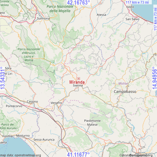
Miranda GPS coordinates[2]
41° 38' 39.624" North, 14° 14' 47.148" East
| Map corner | latitude | longitude |
|---|---|---|
| Upper-left | 42.16763°, | 13.54331° |
| Center: | 41.64434°, | 14.24643° |
| Lower-right: | 41.11677°, | 14.94956° |
| Map W x H: | 116.8×116.8 km | = 72.6×72.6mi |
| max Lat: | 47.04031° ⇑73.5% North |
| Miranda: | 41.64434° |
| min Lat: | ⇓26.5% South 35.50142° |
| min Long | Miranda | max Long |
| 6.69888° | 14.24643° | 18.48682° |
| W 80.3%⇐ | ⇒19.7% E |
Elevation
Elevation of Miranda is 887 m = 2910 ft, and this is 580.3 m = 1904 ft above average elevation for this country.
| Max E: |
2085 m = 6841 ft | 4.8% |
| Miranda | 887 m 2910 ft | |
| Avg. | 306.7 m = 1006 ft | |
Min E: |
-4 m = -13 ft | 95.2% |
See also: Italy elevation on elevation.city.
Geographical zone
Miranda is located in North temperate zone (between Tropic of Cancer and the Arctic Circle). Distance of this Northern Tropic circle is 2024.5 km =1258 mi to South.| Distance of | km | miles | from Miranda |
|---|---|---|---|
| North Pole | 5376.6 | 3340.9 | to North |
| Arctic Circle | 2770.8 | 1721.7 | to North |
| Tropic Cancer | 2024.5 | 1258 | to South |
| Equator | 4630.4 | 2877.2 | to South |


Nearby cities:
15 places around Miranda: (largest is in red/bold)
• Acquaviva d'Isernia
8.7 km =5.4 mi,  290°
290°
• Carovilli
8.6 km =5.3 mi,  27°
27°
• Carpinone
8.9 km =5.5 mi,  132°
132°
• Castelromano
5 km =3.1 mi,  235°
235°
• Forlì del Sannio
8 km =5 mi,  315°
315°
• Fornelli
9.8 km =6.1 mi, 244°
• Isernia
5.5 km =3.4 mi,  190°
190°
• Macchia d'Isernia
11.3 km =7 mi,  214°
214°
• Pesche
5 km =3.1 mi,  150°
150°
• Pescolanciano
8.5 km =5.3 mi,  62°
62°
• Pettoranello del Molise
8.3 km =5.2 mi,  161°
161°
• Rionero Sannitico
11.7 km =7.3 mi,  310°
310°
• Roccasicura
6 km =3.7 mi,  347°
347°
• Sant'Agapito
11.4 km =7.1 mi, 190°
• Sessano del Molise
6.8 km =4.2 mi,  94°
94°
Sources, notices
• [Note1] Compared only with cities in Italy existing in our database
• [Src1] Map data: © OpenStreetMap contributors (CC-BY-SA)
• [Src2] Other city data from geonames.org with taken over terms of usage.
• [Src3] Geographical zone / Annual Mean Temperature by Robert A. Rohde @ Wikipedia
