Martellago geodata
Martellago (Veneto) is a seat of a third-order administrative division; located in Italy in Europe/Rome (GMT+2) time zone. With population of 7,224 people, there are 1350 cities with bigger population in this country. Compared to other cities in Italy, 75.1% of cities are located further ↓South; 58.1% of cities are located further ←West and 94.8% of cities have higher elevation than Martellago. Note1


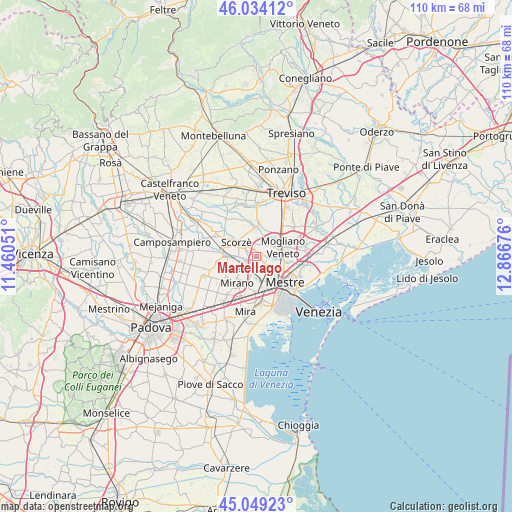
Martellago GPS coordinates[2]
45° 32' 37.788" North, 12° 9' 49.068" East
| Map corner | latitude | longitude |
|---|---|---|
| Upper-left | 46.03412°, | 11.46051° |
| Center: | 45.54383°, | 12.16363° |
| Lower-right: | 45.04923°, | 12.86676° |
| Map W x H: | 109.5×109.5 km | = 68×68mi |
| max Lat: | 47.04031° ⇑24.9% North |
| Martellago: | 45.54383° |
| min Lat: | ⇓75.1% South 35.50142° |
| min Long | Martellago | max Long |
| 6.69888° | 12.16363° | 18.48682° |
| W 58.1%⇐ | ⇒41.9% E |
Elevation
Elevation of Martellago is 9 m = 30 ft, and this is 297.7 m = 977 ft below average elevation for this country.
| Max E: |
2085 m = 6841 ft | 94.8% |
| Avg. | 306.7 m = 1006 ft | |
| Martellago | 9 m = 30 ft | |
Min E: |
-4 m = -13 ft | 5.2% |
See also: Italy elevation on elevation.city.
Geographical zone
Martellago is located in North temperate zone (between Tropic of Cancer and the Arctic Circle). Distance of this North polar circle is 2337.2 km =1452.3 mi to North.| Distance of | km | miles | from Martellago |
|---|---|---|---|
| North Pole | 4943.1 | 3071.5 | to North |
| Arctic Circle | 2337.2 | 1452.3 | to North |
| Tropic Cancer | 2458.1 | 1527.4 | to South |
| Equator | 5064 | 3146.6 | to South |


Nearby cities:
15 places around Martellago: (largest is in red/bold)
• Campocroce
6.2 km =3.9 mi,  42°
42°
• Cappella
3.3 km =2.1 mi,  327°
327°
• Case Dosa
5.7 km =3.5 mi,  148°
148°
• Fossa
6 km =3.7 mi,  201°
201°
• Maerne
2.4 km =1.5 mi, 196°
• Marocco
5.3 km =3.3 mi,  100°
100°
• Mogliano Veneto
6.3 km =3.9 mi,  77°
77°
• Peseggia-Gardigiano
2.3 km =1.4 mi,  31°
31°
• Robegano
3.5 km =2.2 mi,  267°
267°
• Salzano
5.4 km =3.4 mi,  243°
243°
• Scorzè
5.3 km =3.3 mi,  309°
309°
• Spinea-Orgnano
5.9 km =3.7 mi,  186°
186°
• Trivignano
2.2 km =1.4 mi,  126°
126°
• Zelarino
4.7 km =2.9 mi, 132°
• Zero Branco
6.2 km =3.9 mi,  0°
0°
Sources, notices
• [Note1] Compared only with cities in Italy existing in our database
• [Src1] Map data: © OpenStreetMap contributors (CC-BY-SA)
• [Src2] Other city data from geonames.org with taken over terms of usage.
• [Src3] Geographical zone / Annual Mean Temperature by Robert A. Rohde @ Wikipedia
