Trivignano geodata
Trivignano (Veneto) is a populated place; located in Italy in Europe/Rome (GMT+2) time zone. With population of 2,227 people, there are 3832 cities with bigger population in this country. Compared to other cities in Italy, 74.7% of cities are located further ↓South; 58.5% of cities are located further ←West and 95.9% of cities have higher elevation than Trivignano. Note1


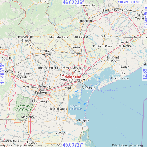
Trivignano GPS coordinates[2]
45° 31' 55.092" North, 12° 11' 12.732" East
| Map corner | latitude | longitude |
|---|---|---|
| Upper-left | 46.02236°, | 11.48375° |
| Center: | 45.53197°, | 12.18687° |
| Lower-right: | 45.03727°, | 12.89° |
| Map W x H: | 109.5×109.5 km | = 68×68mi |
| max Lat: | 47.04031° ⇑25.3% North |
| Trivignano: | 45.53197° |
| min Lat: | ⇓74.7% South 35.50142° |
| min Long | Trivignano | max Long |
| 6.69888° | 12.18687° | 18.48682° |
| W 58.5%⇐ | ⇒41.5% E |
Elevation
Elevation of Trivignano is 7 m = 23 ft, and this is 299.7 m = 983 ft below average elevation for this country.
| Max E: |
2085 m = 6841 ft | 95.9% |
| Avg. | 306.7 m = 1006 ft | |
| Trivignano | 7 m = 23 ft | |
Min E: |
-4 m = -13 ft | 4.1% |
See also: Italy elevation on elevation.city.
Geographical zone
Trivignano is located in North temperate zone (between Tropic of Cancer and the Arctic Circle). Distance of this North polar circle is 2338.5 km =1453.1 mi to North.| Distance of | km | miles | from Trivignano |
|---|---|---|---|
| North Pole | 4944.4 | 3072.3 | to North |
| Arctic Circle | 2338.5 | 1453.1 | to North |
| Tropic Cancer | 2456.8 | 1526.6 | to South |
| Equator | 5062.7 | 3145.8 | to South |


Nearby cities:
15 places around Trivignano: (largest is in red/bold)
• Campocroce
6.3 km =3.9 mi,  21°
21°
• Cappella
5.5 km =3.4 mi,  318°
318°
• Case Dosa
3.7 km =2.3 mi,  162°
162°
• Fornase
6.5 km =4 mi,  196°
196°
• Fossa
5.8 km =3.6 mi,  223°
223°
• Maerne
2.7 km =1.7 mi,  248°
248°
• Marocco
3.4 km =2.1 mi,  83°
83°
• Martellago
2.2 km =1.4 mi,  306°
306°
• Mestre
6.4 km =4 mi,  134°
134°
• Mogliano Veneto
5.1 km =3.2 mi,  58°
58°
• Peseggia-Gardigiano
3.4 km =2.1 mi,  350°
350°
• Robegano
5.4 km =3.4 mi,  282°
282°
• Salzano
6.7 km =4.2 mi,  260°
260°
• Spinea-Orgnano
5.2 km =3.2 mi,  208°
208°
• Zelarino
2.5 km =1.6 mi,  138°
138°
Sources, notices
• [Note1] Compared only with cities in Italy existing in our database
• [Src1] Map data: © OpenStreetMap contributors (CC-BY-SA)
• [Src2] Other city data from geonames.org with taken over terms of usage.
• [Src3] Geographical zone / Annual Mean Temperature by Robert A. Rohde @ Wikipedia
