Salzano geodata
Salzano (Veneto) is a seat of a third-order administrative division; located in Italy in Europe/Rome (GMT+2) time zone. With population of 7,450 people, there are 1307 cities with bigger population in this country. Compared to other cities in Italy, 74.4% of cities are located further ↓South; 57.3% of cities are located further ←West and 94.8% of cities have higher elevation than Salzano. Note1


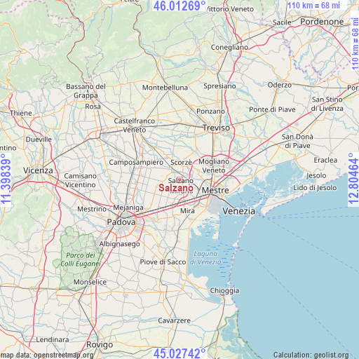
Salzano GPS coordinates[2]
45° 31' 19.956" North, 12° 6' 5.436" East
| Map corner | latitude | longitude |
|---|---|---|
| Upper-left | 46.01269°, | 11.39839° |
| Center: | 45.52221°, | 12.10151° |
| Lower-right: | 45.02742°, | 12.80464° |
| Map W x H: | 109.6×109.5 km | = 68.1×68mi |
| max Lat: | 47.04031° ⇑25.6% North |
| Salzano: | 45.52221° |
| min Lat: | ⇓74.4% South 35.50142° |
| min Long | Salzano | max Long |
| 6.69888° | 12.10151° | 18.48682° |
| W 57.3%⇐ | ⇒42.7% E |
Elevation
Elevation of Salzano is 9 m = 30 ft, and this is 297.7 m = 977 ft below average elevation for this country.
| Max E: |
2085 m = 6841 ft | 94.8% |
| Avg. | 306.7 m = 1006 ft | |
| Salzano | 9 m = 30 ft | |
Min E: |
-4 m = -13 ft | 5.2% |
See also: Italy elevation on elevation.city.
Geographical zone
Salzano is located in North temperate zone (between Tropic of Cancer and the Arctic Circle). Distance of this North polar circle is 2339.6 km =1453.8 mi to North.| Distance of | km | miles | from Salzano |
|---|---|---|---|
| North Pole | 4945.5 | 3073 | to North |
| Arctic Circle | 2339.6 | 1453.8 | to North |
| Tropic Cancer | 2455.7 | 1525.9 | to South |
| Equator | 5061.6 | 3145.1 | to South |


Nearby cities:
15 places around Salzano: (largest is in red/bold)
• Cappella
6 km =3.7 mi,  30°
30°
• Cavin-Botti
3.9 km =2.4 mi,  230°
230°
• Fossa
4.1 km =2.5 mi,  140°
140°
• Maerne
4.2 km =2.6 mi,  88°
88°
• Martellago
5.4 km =3.4 mi,  63°
63°
• Mirano
3.1 km =1.9 mi,  171°
171°
• Moniego
4.5 km =2.8 mi,  345°
345°
• Noale
3.9 km =2.4 mi,  312°
312°
• Robegano
2.6 km =1.6 mi, 31°
• Santa Maria di Sala
5.4 km =3.4 mi,  251°
251°
• Scaltenigo
5.9 km =3.7 mi,  195°
195°
• Scorzè
5.8 km =3.6 mi,  7°
7°
• Spinea-Orgnano
5.4 km =3.4 mi,  129°
129°
• Stigliano
4.5 km =2.8 mi,  271°
271°
• Veternigo
3.4 km =2.1 mi,  261°
261°
Sources, notices
• [Note1] Compared only with cities in Italy existing in our database
• [Src1] Map data: © OpenStreetMap contributors (CC-BY-SA)
• [Src2] Other city data from geonames.org with taken over terms of usage.
• [Src3] Geographical zone / Annual Mean Temperature by Robert A. Rohde @ Wikipedia
