Robegano geodata
Robegano (Veneto) is a populated place; located in Italy in Europe/Rome (GMT+2) time zone. With population of 2,640 people, there are 3380 cities with bigger population in this country. Compared to other cities in Italy, 75.1% of cities are located further ↓South; 57.6% of cities are located further ←West and 93.6% of cities have higher elevation than Robegano. Note1


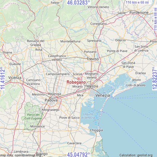
Robegano GPS coordinates[2]
45° 32' 33.108" North, 12° 7' 9.264" East
| Map corner | latitude | longitude |
|---|---|---|
| Upper-left | 46.03283°, | 11.41612° |
| Center: | 45.54253°, | 12.11924° |
| Lower-right: | 45.04792°, | 12.82237° |
| Map W x H: | 109.5×109.5 km | = 68×68mi |
| max Lat: | 47.04031° ⇑24.9% North |
| Robegano: | 45.54253° |
| min Lat: | ⇓75.1% South 35.50142° |
| min Long | Robegano | max Long |
| 6.69888° | 12.11924° | 18.48682° |
| W 57.6%⇐ | ⇒42.4% E |
Elevation
Elevation of Robegano is 11 m = 36 ft, and this is 295.7 m = 970 ft below average elevation for this country.
| Max E: |
2085 m = 6841 ft | 93.6% |
| Avg. | 306.7 m = 1006 ft | |
| Robegano | 11 m = 36 ft | |
Min E: |
-4 m = -13 ft | 6.4% |
See also: Italy elevation on elevation.city.
Geographical zone
Robegano is located in North temperate zone (between Tropic of Cancer and the Arctic Circle). Distance of this North polar circle is 2337.3 km =1452.3 mi to North.| Distance of | km | miles | from Robegano |
|---|---|---|---|
| North Pole | 4943.2 | 3071.6 | to North |
| Arctic Circle | 2337.3 | 1452.3 | to North |
| Tropic Cancer | 2457.9 | 1527.3 | to South |
| Equator | 5063.9 | 3146.6 | to South |


Nearby cities:
15 places around Robegano: (largest is in red/bold)
• Cappella
3.4 km =2.1 mi,  29°
29°
• Cappelletta
5.4 km =3.4 mi,  304°
304°
• Fossa
5.6 km =3.5 mi,  166°
166°
• Maerne
3.5 km =2.2 mi,  127°
127°
• Martellago
3.5 km =2.2 mi,  87°
87°
• Mirano
5.4 km =3.4 mi,  189°
189°
• Moniego
3.3 km =2.1 mi,  309°
309°
• Noale
4.3 km =2.7 mi,  275°
275°
• Peseggia-Gardigiano
5.1 km =3.2 mi,  65°
65°
• Rio San Martino
5.6 km =3.5 mi,  353°
353°
• Salzano
2.6 km =1.6 mi,  211°
211°
• Scorzè
3.6 km =2.2 mi, 350°
• Stigliano
6.2 km =3.9 mi,  250°
250°
• Trivignano
5.4 km =3.4 mi,  102°
102°
• Veternigo
5.5 km =3.4 mi,  239°
239°
Sources, notices
• [Note1] Compared only with cities in Italy existing in our database
• [Src1] Map data: © OpenStreetMap contributors (CC-BY-SA)
• [Src2] Other city data from geonames.org with taken over terms of usage.
• [Src3] Geographical zone / Annual Mean Temperature by Robert A. Rohde @ Wikipedia
