Marostica geodata
Marostica (Veneto) is a seat of a third-order administrative division; located in Italy in Europe/Rome (GMT+2) time zone. With population of 9,264 people, there are 1021 cities with bigger population in this country. Compared to other cities in Italy, 83.3% of cities are located further ↓South; 51.3% of cities are located further ←West and 69.6% of cities have higher elevation than Marostica. Note1


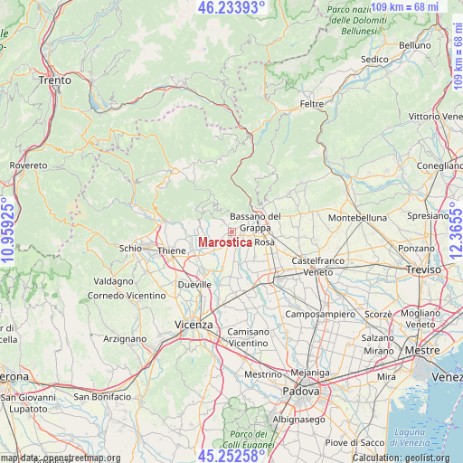
Marostica GPS coordinates[2]
45° 44' 43.476" North, 11° 39' 44.532" East
| Map corner | latitude | longitude |
|---|---|---|
| Upper-left | 46.23393°, | 10.95925° |
| Center: | 45.74541°, | 11.66237° |
| Lower-right: | 45.25258°, | 12.3655° |
| Map W x H: | 109.1×109.1 km | = 67.8×67.8mi |
| max Lat: | 47.04031° ⇑16.7% North |
| Marostica: | 45.74541° |
| min Lat: | ⇓83.3% South 35.50142° |
| min Long | Marostica | max Long |
| 6.69888° | 11.66237° | 18.48682° |
| W 51.3%⇐ | ⇒48.7% E |
Elevation
Elevation of Marostica is 100 m = 328 ft, and this is 206.7 m = 678 ft below average elevation for this country.
| Max E: |
2085 m = 6841 ft | 69.6% |
| Avg. | 306.7 m = 1006 ft | |
| Marostica | 100 m = 328 ft | |
Min E: |
-4 m = -13 ft | 30.4% |
See also: Italy elevation on elevation.city.
Geographical zone
Marostica is located in North temperate zone (between Tropic of Cancer and the Arctic Circle). Distance of this North polar circle is 2314.8 km =1438.3 mi to North.| Distance of | km | miles | from Marostica |
|---|---|---|---|
| North Pole | 4920.6 | 3057.5 | to North |
| Arctic Circle | 2314.8 | 1438.3 | to North |
| Tropic Cancer | 2480.5 | 1541.3 | to South |
| Equator | 5086.4 | 3160.5 | to South |


Nearby cities:
15 places around Marostica: (largest is in red/bold)
• Bassano del Grappa
5.6 km =3.5 mi,  65°
65°
• Cartigliano
4.4 km =2.7 mi,  144°
144°
• Conco
7.4 km =4.6 mi,  326°
326°
• Longa
7.4 km =4.6 mi,  192°
192°
• Mason Vicentino
5.2 km =3.2 mi,  235°
235°
• Mure
4.2 km =2.6 mi,  252°
252°
• Nove
2.9 km =1.8 mi,  154°
154°
• Pianezze
2.8 km =1.7 mi,  260°
260°
• Provinciale Gasparona
2.3 km =1.4 mi, 242°
• San Michele
4.2 km =2.6 mi,  32°
32°
• Schiavon
5.6 km =3.5 mi, 193°
• Tezze
7 km =4.3 mi, 150°
• Valrovina
5.1 km =3.2 mi,  23°
23°
• Villa di Molvena
3.6 km =2.2 mi,  234°
234°
• Villaraspa
4.1 km =2.5 mi,  222°
222°
Sources, notices
• [Note1] Compared only with cities in Italy existing in our database
• [Src1] Map data: © OpenStreetMap contributors (CC-BY-SA)
• [Src2] Other city data from geonames.org with taken over terms of usage.
• [Src3] Geographical zone / Annual Mean Temperature by Robert A. Rohde @ Wikipedia
