Longa geodata
Longa (Veneto) is a populated place; located in Italy in Europe/Rome (GMT+2) time zone. With population of 942 people, there are 6911 cities with bigger population in this country. Compared to other cities in Italy, 80.3% of cities are located further ↓South; 51.1% of cities are located further ←West and 75.9% of cities have higher elevation than Longa. Note1


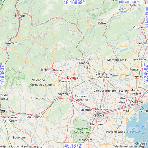
Longa GPS coordinates[2]
45° 40' 50.16" North, 11° 38' 32.964" East
| Map corner | latitude | longitude |
|---|---|---|
| Upper-left | 46.16969°, | 10.93937° |
| Center: | 45.6806°, | 11.64249° |
| Lower-right: | 45.1872°, | 12.34562° |
| Map W x H: | 109.2×109.2 km | = 67.9×67.9mi |
| max Lat: | 47.04031° ⇑19.7% North |
| Longa: | 45.6806° |
| min Lat: | ⇓80.3% South 35.50142° |
| min Long | Longa | max Long |
| 6.69888° | 11.64249° | 18.48682° |
| W 51.1%⇐ | ⇒48.9% E |
Elevation
Elevation of Longa is 70 m = 230 ft, and this is 236.7 m = 777 ft below average elevation for this country.
| Max E: |
2085 m = 6841 ft | 75.9% |
| Avg. | 306.7 m = 1006 ft | |
| Longa | 70 m = 230 ft | |
Min E: |
-4 m = -13 ft | 24.1% |
See also: Italy elevation on elevation.city.
Geographical zone
Longa is located in North temperate zone (between Tropic of Cancer and the Arctic Circle). Distance of this North polar circle is 2322 km =1442.8 mi to North.| Distance of | km | miles | from Longa |
|---|---|---|---|
| North Pole | 4927.9 | 3062.1 | to North |
| Arctic Circle | 2322 | 1442.8 | to North |
| Tropic Cancer | 2473.3 | 1536.8 | to South |
| Equator | 5079.2 | 3156.1 | to South |


Nearby cities:
15 places around Longa: (largest is in red/bold)
• Ancignano
2.3 km =1.4 mi,  203°
203°
• Bressanvido
3.8 km =2.4 mi,  189°
189°
• Camazzole
5.8 km =3.6 mi,  130°
130°
• Cartigliano
5.5 km =3.4 mi,  48°
48°
• Friola
2.8 km =1.7 mi,  96°
96°
• Maragnole
3 km =1.9 mi,  282°
282°
• Mason Vicentino
5.1 km =3.2 mi,  326°
326°
• Nove
5.3 km =3.3 mi,  31°
31°
• Poianella
5.7 km =3.5 mi, 191°
• Pozzoleone
4.1 km =2.5 mi,  147°
147°
• Sandrigo
4.7 km =2.9 mi,  242°
242°
• Schiavon
1.8 km =1.1 mi,  8°
8°
• Tezze
5.1 km =3.2 mi,  78°
78°
• Villa di Molvena
5.3 km =3.3 mi,  344°
344°
• Villaraspa
4.4 km =2.7 mi, 343°
Sources, notices
• [Note1] Compared only with cities in Italy existing in our database
• [Src1] Map data: © OpenStreetMap contributors (CC-BY-SA)
• [Src2] Other city data from geonames.org with taken over terms of usage.
• [Src3] Geographical zone / Annual Mean Temperature by Robert A. Rohde @ Wikipedia
