Cartigliano geodata
Cartigliano (Veneto) is a seat of a third-order administrative division; located in Italy in Europe/Rome (GMT+2) time zone. With population of 3,218 people, there are 2887 cities with bigger population in this country. Compared to other cities in Italy, 81.8% of cities are located further ↓South; 51.7% of cities are located further ←West and 72.3% of cities have higher elevation than Cartigliano. Note1


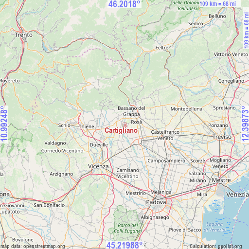
Cartigliano GPS coordinates[2]
45° 42' 46.8" North, 11° 41' 44.16" East
| Map corner | latitude | longitude |
|---|---|---|
| Upper-left | 46.2018°, | 10.99248° |
| Center: | 45.713°, | 11.6956° |
| Lower-right: | 45.21988°, | 12.39873° |
| Map W x H: | 109.2×109.2 km | = 67.9×67.9mi |
| max Lat: | 47.04031° ⇑18.2% North |
| Cartigliano: | 45.713° |
| min Lat: | ⇓81.8% South 35.50142° |
| min Long | Cartigliano | max Long |
| 6.69888° | 11.6956° | 18.48682° |
| W 51.7%⇐ | ⇒48.3% E |
Elevation
Elevation of Cartigliano is 86 m = 282 ft, and this is 220.7 m = 724 ft below average elevation for this country.
| Max E: |
2085 m = 6841 ft | 72.3% |
| Avg. | 306.7 m = 1006 ft | |
| Cartigliano | 86 m = 282 ft | |
Min E: |
-4 m = -13 ft | 27.7% |
See also: Italy elevation on elevation.city.
Geographical zone
Cartigliano is located in North temperate zone (between Tropic of Cancer and the Arctic Circle). Distance of this North polar circle is 2318.4 km =1440.6 mi to North.| Distance of | km | miles | from Cartigliano |
|---|---|---|---|
| North Pole | 4924.3 | 3059.8 | to North |
| Arctic Circle | 2318.4 | 1440.6 | to North |
| Tropic Cancer | 2476.9 | 1539.1 | to South |
| Equator | 5082.8 | 3158.3 | to South |


Nearby cities:
15 places around Cartigliano: (largest is in red/bold)
• Bassano del Grappa
6.4 km =4 mi,  22°
22°
• Belvedere
6.4 km =4 mi,  113°
113°
• Friola
4.1 km =2.5 mi,  198°
198°
• Longa
5.5 km =3.4 mi,  228°
228°
• Marostica
4.4 km =2.7 mi,  324°
324°
• Mason Vicentino
6.9 km =4.3 mi,  275°
275°
• Nove
1.6 km =1 mi,  305°
305°
• Pianezze
6.2 km =3.9 mi,  300°
300°
• Provinciale Gasparona
5.3 km =3.3 mi, 298°
• Rosà
5.3 km =3.3 mi,  103°
103°
• Santa Croce Bigolina
5.6 km =3.5 mi,  161°
161°
• Schiavon
4.3 km =2.7 mi,  244°
244°
• Tezze
2.7 km =1.7 mi, 161°
• Villa di Molvena
5.7 km =3.5 mi,  285°
285°
• Villaraspa
5.4 km =3.4 mi, 276°
Sources, notices
• [Note1] Compared only with cities in Italy existing in our database
• [Src1] Map data: © OpenStreetMap contributors (CC-BY-SA)
• [Src2] Other city data from geonames.org with taken over terms of usage.
• [Src3] Geographical zone / Annual Mean Temperature by Robert A. Rohde @ Wikipedia
