Sant'Anastasia geodata
Sant'Anastasia (Campania) is a seat of a third-order administrative division; located in Italy in Europe/Rome (GMT+2) time zone. With population of 20,733 people, there are 424 cities with bigger population in this country. Compared to other cities in Italy, 80.5% of cities are located further ↑North; 81.8% of cities are located further ←West and 62.3% of cities have higher elevation than Sant'Anastasia. Note1


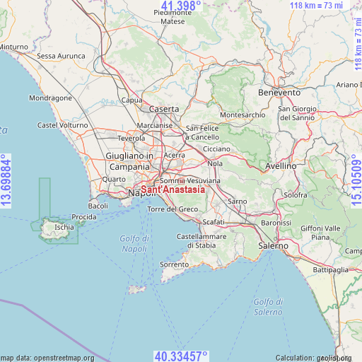
Sant'Anastasia GPS coordinates[2]
40° 52' 6.312" North, 14° 24' 7.056" East
| Map corner | latitude | longitude |
|---|---|---|
| Upper-left | 41.398°, | 13.69884° |
| Center: | 40.86842°, | 14.40196° |
| Lower-right: | 40.33457°, | 15.10509° |
| Map W x H: | 118.2×118.2 km | = 73.4×73.4mi |
| max Lat: | 47.04031° ⇑80.5% North |
| Sant'Anastasia: | 40.86842° |
| min Lat: | ⇓19.5% South 35.50142° |
| min Long | Sant'Anastasia | max Long |
| 6.69888° | 14.40196° | 18.48682° |
| W 81.8%⇐ | ⇒18.2% E |
Elevation
Elevation of Sant'Anastasia is 147 m = 482 ft, and this is 159.7 m = 524 ft below average elevation for this country.
| Max E: |
2085 m = 6841 ft | 62.3% |
| Avg. | 306.7 m = 1006 ft | |
| Sant'Anastasia | 147 m = 482 ft | |
Min E: |
-4 m = -13 ft | 37.7% |
See also: Italy elevation on elevation.city.
Geographical zone
Sant'Anastasia is located in North temperate zone (between Tropic of Cancer and the Arctic Circle). Distance of this Northern Tropic circle is 1938.2 km =1204.3 mi to South.| Distance of | km | miles | from Sant'Anastasia |
|---|---|---|---|
| North Pole | 5462.9 | 3394.5 | to North |
| Arctic Circle | 2857 | 1775.3 | to North |
| Tropic Cancer | 1938.2 | 1204.3 | to South |
| Equator | 4544.1 | 2823.6 | to South |


Nearby cities:
15 places around Sant'Anastasia: (largest is in red/bold)
• Brusciano
6.3 km =3.9 mi,  17°
17°
• Casarea
3.9 km =2.4 mi,  304°
304°
• Castello di Cisterna
5.3 km =3.3 mi,  8°
8°
• Cercola
3.9 km =2.4 mi,  256°
256°
• Massa di Somma
3.4 km =2.1 mi,  221°
221°
• Musci
3.2 km =2 mi,  290°
290°
• Pollena Trocchia
2.7 km =1.7 mi,  225°
225°
• Pomigliano d'Arco
4.9 km =3 mi,  341°
341°
• Ponte di Ferro
2 km =1.2 mi, 340°
• Ponticelli
6.2 km =3.9 mi, 255°
• San Sebastiano al Vesuvio
4.2 km =2.6 mi, 228°
• Somma Vesuviana
3.1 km =1.9 mi,  80°
80°
• Spartimento
6.4 km =4 mi,  66°
66°
• Starza Vecchia
2.4 km =1.5 mi,  358°
358°
• Volla
5.2 km =3.2 mi,  276°
276°
Sources, notices
• [Note1] Compared only with cities in Italy existing in our database
• [Src1] Map data: © OpenStreetMap contributors (CC-BY-SA)
• [Src2] Other city data from geonames.org with taken over terms of usage.
• [Src3] Geographical zone / Annual Mean Temperature by Robert A. Rohde @ Wikipedia
