Raito geodata
Raito (Campania) is a populated place; located in Italy in Europe/Rome (GMT+2) time zone. With population of 938 people, there are 6940 cities with bigger population in this country. Compared to other cities in Italy, 82.7% of cities are located further ↑North; 84.6% of cities are located further ←West and 66.9% of cities have higher elevation than Raito. Note1
Administrative division(s):
- Level 1: Campania
- Level 2: Provincia di Salerno
- Level 3: Vietri sul Mare


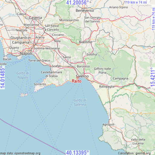
Raito GPS coordinates[2]
40° 40' 9.804" North, 14° 43' 4.692" East
| Map corner | latitude | longitude |
|---|---|---|
| Upper-left | 41.20056°, | 14.01485° |
| Center: | 40.66939°, | 14.71797° |
| Lower-right: | 40.13395°, | 15.4211° |
| Map W x H: | 118.6×118.6 km | = 73.7×73.7mi |
| max Lat: | 47.04031° ⇑82.7% North |
| Raito: | 40.66939° |
| min Lat: | ⇓17.3% South 35.50142° |
| min Long | Raito | max Long |
| 6.69888° | 14.71797° | 18.48682° |
| W 84.6%⇐ | ⇒15.4% E |
Elevation
Elevation of Raito is 116 m = 381 ft, and this is 190.7 m = 626 ft below average elevation for this country.
| Max E: |
2085 m = 6841 ft | 66.9% |
| Avg. | 306.7 m = 1006 ft | |
| Raito | 116 m = 381 ft | |
Min E: |
-4 m = -13 ft | 33.1% |
See also: Italy elevation on elevation.city.
Geographical zone
Raito is located in North temperate zone (between Tropic of Cancer and the Arctic Circle). Distance of this Northern Tropic circle is 1916.1 km =1190.6 mi to South.| Distance of | km | miles | from Raito |
|---|---|---|---|
| North Pole | 5485 | 3408.2 | to North |
| Arctic Circle | 2879.2 | 1789.1 | to North |
| Tropic Cancer | 1916.1 | 1190.6 | to South |
| Equator | 4522 | 2809.8 | to South |


Nearby cities:
15 places around Raito: (largest is in red/bold)
• Capezzano Inferiore
5.8 km =3.6 mi,  53°
53°
• Capezzano-Cologna
6.9 km =4.3 mi,  42°
42°
• Cava Dè Tirreni
3.5 km =2.2 mi,  345°
345°
• Cetara
2.8 km =1.7 mi,  210°
210°
• Coperchia
7 km =4.3 mi, 36°
• Corpo di Cava
2.9 km =1.8 mi,  302°
302°
• Dragonea
1.2 km =0.7 mi,  331°
331°
• Maiori
6.9 km =4.3 mi,  250°
250°
• Molina
1.5 km =0.9 mi,  8°
8°
• Pellezzano
7 km =4.3 mi,  28°
28°
• Polvica
7.1 km =4.4 mi,  293°
293°
• Salerno
6.4 km =4 mi,  83°
83°
• Sant'Anna I
7.1 km =4.4 mi,  355°
355°
• Tramonti
6.6 km =4.1 mi, 291°
• Vietri sul Mare
0.7 km =0.4 mi, 82°
Sources, notices
• [Note1] Compared only with cities in Italy existing in our database
• [Src1] Map data: © OpenStreetMap contributors (CC-BY-SA)
• [Src2] Other city data from geonames.org with taken over terms of usage.
• [Src3] Geographical zone / Annual Mean Temperature by Robert A. Rohde @ Wikipedia
