Maggio geodata
Maggio (Lombardy) is a populated place; located in Italy in Europe/Rome (GMT+2) time zone. With population of 725 people, there are 8122 cities with bigger population in this country. Compared to other cities in Italy, 89.9% of cities are located further ↓South; 73.8% of cities are located further →East and 92.1% of cities have lower elevation than Maggio. Note1


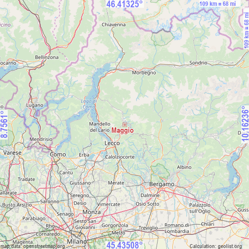
Maggio GPS coordinates[2]
45° 55' 34.752" North, 9° 27' 33.228" East
| Map corner | latitude | longitude |
|---|---|---|
| Upper-left | 46.41325°, | 8.7561° |
| Center: | 45.92632°, | 9.45923° |
| Lower-right: | 45.43508°, | 10.16236° |
| Map W x H: | 108.8×108.8 km | = 67.6×67.6mi |
| max Lat: | 47.04031° ⇑10.1% North |
| Maggio: | 45.92632° |
| min Lat: | ⇓89.9% South 35.50142° |
| min Long | Maggio | max Long |
| 6.69888° | 9.45923° | 18.48682° |
| W 26.2%⇐ | ⇒73.8% E |
Elevation
Elevation of Maggio is 774 m = 2539 ft, and this is 467.3 m = 1533 ft above average elevation for this country.
| Max E: |
2085 m = 6841 ft | 7.9% |
| Maggio | 774 m 2539 ft | |
| Avg. | 306.7 m = 1006 ft | |
Min E: |
-4 m = -13 ft | 92.1% |
See also: Italy elevation on elevation.city.
Geographical zone
Maggio is located in North temperate zone (between Tropic of Cancer and the Arctic Circle). Distance of this North polar circle is 2294.6 km =1425.8 mi to North.| Distance of | km | miles | from Maggio |
|---|---|---|---|
| North Pole | 4900.5 | 3045 | to North |
| Arctic Circle | 2294.6 | 1425.8 | to North |
| Tropic Cancer | 2500.6 | 1553.8 | to South |
| Equator | 5106.5 | 3173 | to South |


Nearby cities:
15 places around Maggio: (largest is in red/bold)
• Ballabio
4.4 km =2.7 mi,  220°
220°
• Barzio
2 km =1.2 mi,  17°
17°
• Brumano
8.6 km =5.3 mi,  158°
158°
• Cassina Valsassina
1.7 km =1.1 mi,  67°
67°
• Cremeno
1.3 km =0.8 mi,  43°
43°
• Fuipiano Valle Imagna
9.6 km =6 mi,  146°
146°
• Introbio
5.3 km =3.3 mi,  352°
352°
• Lecco
9.2 km =5.7 mi,  211°
211°
• Moggio
2.2 km =1.4 mi, 72°
• Morterone
6 km =3.7 mi, 162°
• Pasturo
3.1 km =1.9 mi,  337°
337°
• Primaluna
6.6 km =4.1 mi, 345°
• Taleggio
9 km =5.6 mi,  114°
114°
• Valtorta
8.1 km =5 mi,  46°
46°
• Vedeseta
7.3 km =4.5 mi,  122°
122°
Sources, notices
• [Note1] Compared only with cities in Italy existing in our database
• [Src1] Map data: © OpenStreetMap contributors (CC-BY-SA)
• [Src2] Other city data from geonames.org with taken over terms of usage.
• [Src3] Geographical zone / Annual Mean Temperature by Robert A. Rohde @ Wikipedia
