Morterone geodata
Morterone (Lombardy) is a seat of a third-order administrative division; located in Italy in Europe/Rome (GMT+2) time zone. With population of 2 people, there are 11705 cities with bigger population in this country. Compared to other cities in Italy, 88.4% of cities are located further ↓South; 73.5% of cities are located further →East and 97.5% of cities have lower elevation than Morterone. Note1


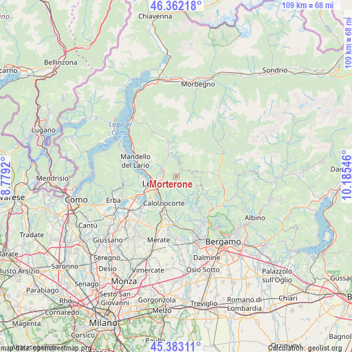
Morterone GPS coordinates[2]
45° 52' 29.28" North, 9° 28' 56.388" East
| Map corner | latitude | longitude |
|---|---|---|
| Upper-left | 46.36218°, | 8.7792° |
| Center: | 45.8748°, | 9.48233° |
| Lower-right: | 45.38311°, | 10.18546° |
| Map W x H: | 108.9×108.9 km | = 67.7×67.7mi |
| max Lat: | 47.04031° ⇑11.6% North |
| Morterone: | 45.8748° |
| min Lat: | ⇓88.4% South 35.50142° |
| min Long | Morterone | max Long |
| 6.69888° | 9.48233° | 18.48682° |
| W 26.5%⇐ | ⇒73.5% E |
Elevation
Elevation of Morterone is 1047 m = 3435 ft, and this is 740.3 m = 2429 ft above average elevation for this country.
| Max E: |
2085 m = 6841 ft | 2.5% |
| Morterone | 1047 m 3435 ft | |
| Avg. | 306.7 m = 1006 ft | |
Min E: |
-4 m = -13 ft | 97.5% |
See also: Italy elevation on elevation.city.
Geographical zone
Morterone is located in North temperate zone (between Tropic of Cancer and the Arctic Circle). Distance of this North polar circle is 2300.4 km =1429.4 mi to North.| Distance of | km | miles | from Morterone |
|---|---|---|---|
| North Pole | 4906.3 | 3048.6 | to North |
| Arctic Circle | 2300.4 | 1429.4 | to North |
| Tropic Cancer | 2494.9 | 1550.3 | to South |
| Equator | 5100.8 | 3169.5 | to South |


Nearby cities:
15 places around Morterone: (largest is in red/bold)
• Ballabio
5.2 km =3.2 mi,  297°
297°
• Botta
6.1 km =3.8 mi,  140°
140°
• Brumano
2.7 km =1.7 mi,  147°
147°
• Calchera-Frontale
5.1 km =3.2 mi, 153°
• Cassina Valsassina
6.4 km =4 mi,  357°
357°
• Corna Imagna
6.9 km =4.3 mi, 135°
• Cremeno
6.7 km =4.2 mi,  352°
352°
• Erve
6.3 km =3.9 mi,  201°
201°
• Fuipiano Valle Imagna
4.2 km =2.6 mi,  122°
122°
• Locatello
6 km =3.7 mi, 137°
• Maggio
6 km =3.7 mi,  342°
342°
• Moggio
6.4 km =4 mi,  2°
2°
• Rota d'Imagna
5.4 km =3.4 mi, 154°
• Taleggio
6.7 km =4.2 mi,  72°
72°
• Vedeseta
4.8 km =3 mi, 67°
Sources, notices
• [Note1] Compared only with cities in Italy existing in our database
• [Src1] Map data: © OpenStreetMap contributors (CC-BY-SA)
• [Src2] Other city data from geonames.org with taken over terms of usage.
• [Src3] Geographical zone / Annual Mean Temperature by Robert A. Rohde @ Wikipedia
