Primaluna geodata
Primaluna (Lombardy) is a seat of a third-order administrative division; located in Italy in Europe/Rome (GMT+2) time zone. With population of 2,124 people, there are 3959 cities with bigger population in this country. Compared to other cities in Italy, 91.6% of cities are located further ↓South; 74% of cities are located further →East and 82.6% of cities have lower elevation than Primaluna. Note1


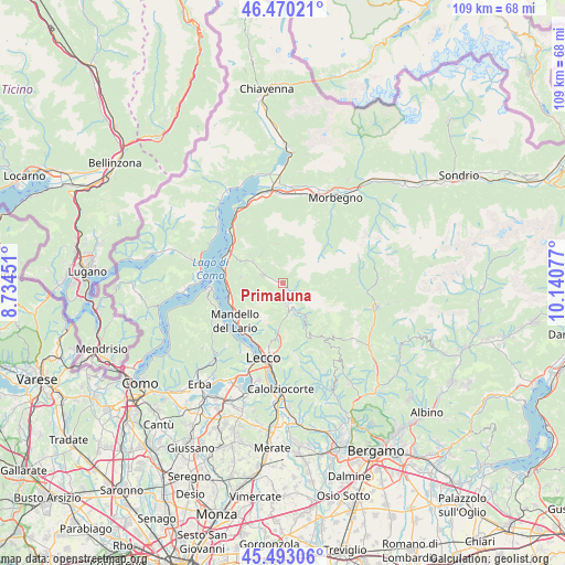
Primaluna GPS coordinates[2]
45° 59' 1.644" North, 9° 26' 15.504" East
| Map corner | latitude | longitude |
|---|---|---|
| Upper-left | 46.47021°, | 8.73451° |
| Center: | 45.98379°, | 9.43764° |
| Lower-right: | 45.49306°, | 10.14077° |
| Map W x H: | 108.6×108.6 km | = 67.5×67.5mi |
| max Lat: | 47.04031° ⇑8.4% North |
| Primaluna: | 45.98379° |
| min Lat: | ⇓91.6% South 35.50142° |
| min Long | Primaluna | max Long |
| 6.69888° | 9.43764° | 18.48682° |
| W 26%⇐ | ⇒74% E |
Elevation
Elevation of Primaluna is 565 m = 1854 ft, and this is 258.3 m = 847 ft above average elevation for this country.
| Max E: |
2085 m = 6841 ft | 17.4% |
| Primaluna | 565 m 1854 ft | |
| Avg. | 306.7 m = 1006 ft | |
Min E: |
-4 m = -13 ft | 82.6% |
See also: Italy elevation on elevation.city.
Geographical zone
Primaluna is located in North temperate zone (between Tropic of Cancer and the Arctic Circle). Distance of this North polar circle is 2288.3 km =1421.9 mi to North.| Distance of | km | miles | from Primaluna |
|---|---|---|---|
| North Pole | 4894.1 | 3041.1 | to North |
| Arctic Circle | 2288.3 | 1421.9 | to North |
| Tropic Cancer | 2507 | 1557.8 | to South |
| Equator | 5112.9 | 3177 | to South |


Nearby cities:
15 places around Primaluna: (largest is in red/bold)
• Barzio
5 km =3.1 mi,  153°
153°
• Casargo
7.3 km =4.5 mi,  327°
327°
• Cassina Valsassina
6.6 km =4.1 mi, 150°
• Cortenova
4.5 km =2.8 mi,  294°
294°
• Crandola Valsassina
6.3 km =3.9 mi,  314°
314°
• Cremeno
6 km =3.7 mi, 154°
• Esino Lario
8.1 km =5 mi,  278°
278°
• Introbio
1.5 km =0.9 mi,  139°
139°
• Maggio
6.6 km =4.1 mi,  165°
165°
• Margno
6.8 km =4.2 mi,  320°
320°
• Moggio
6.8 km =4.2 mi, 146°
• Pasturo
3.6 km =2.2 mi, 171°
• Premana
7.7 km =4.8 mi,  350°
350°
• Taceno
7.1 km =4.4 mi, 307°
• Valtorta
7.5 km =4.7 mi,  95°
95°
Sources, notices
• [Note1] Compared only with cities in Italy existing in our database
• [Src1] Map data: © OpenStreetMap contributors (CC-BY-SA)
• [Src2] Other city data from geonames.org with taken over terms of usage.
• [Src3] Geographical zone / Annual Mean Temperature by Robert A. Rohde @ Wikipedia
